1. Background of ultra-high resolution remote sensing for precision agriculture
The scale of remote sensing resolution determines the scale of precision agriculture. Traditional remote sensing technology is limited by resolution and can only carry out agricultural activities according to the plot as the operation unit. However, if we want to make better use of the potential of arable land resources, scientific and rational use of material inputs, in order to improve crop yield and quality, reduce production costs, reduce the pollution caused by agricultural activities and improve the quality of the environment, then the smallest unit of remote sensing must be further upgraded from the scale of the plot to each plant, and the agricultural big data technology will be developed in the direction of more refinement and integration.
2. Advantages and necessity of technology
UAV technology has a wide range of applications in China's agricultural development, including seeding, fertilization, pest control and other aspects of large-scale agricultural production has a mature application model, but this application is still superficial, rough, from the real precision agriculture is still not a small gap.
Therefore, Ruibao technology combined with its own technology accumulation in the field of visible light sensor for many years, developed a high-precision visible light camera specialized in agricultural inspections.
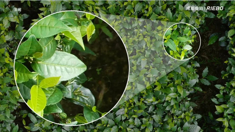
2.1 High-precision visible light camera can provide high-resolution images, even the tiny details can be clearly visible, with a wide range of application value.
Crop monitoring and assessment: High-precision visible light cameras can be used to monitor the growth status of crops in real time, such as leaf color, shape, size, etc., so as to determine whether the growth of crops is healthy or not. Through the processing and analysis of the image, more information about the growth of the crop can also be extracted, such as growth rate, density and so on;
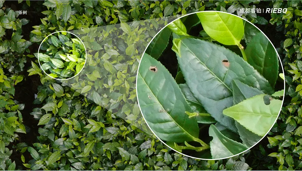
Pest and disease detection: High-precision visible light cameras can capture abnormalities such as disease spots and insect holes on crop leaves, helping farmers detect pest and disease problems in a timely manner. By comparing images of normal and abnormal leaves, the type and extent of pests and diseases can be determined;
Precision agriculture practice: Combining the image data of visible cameras and geographic information system (GIS) technology, precision agriculture practice can be realized through the precise division of farmland and real-time monitoring of crop growth;
Intelligent agricultural equipment: visible light cameras can also be combined with intelligent agricultural equipment to achieve automated inspection and monitoring of farmland, these equipment can be equipped with visible light cameras to carry out large-area farmland inspection, which greatly saves the cost of manpower and improves the inspection efficiency.
2.2 The application of high-precision visible light UAV inspection in agriculture can bring significant economic and social benefits to the agricultural field.
Economic benefits:
Cost reduction: Traditional agricultural monitoring methods often require a large amount of human and material input, while high-precision visible light UAV inspections can cover a large area in a short period of time, reducing the need for a large amount of manpower and thus reducing costs.
Accurate decision-making: With high-definition images collected by drones, agricultural operators can more accurately understand crop growth, pest and disease distribution, and other information, so that they can make more accurate decisions, such as fertilizer application, irrigation, and spraying, which improves the efficiency of resource utilization.
Yield Enhancement: Based on the data collected from drone images, agricultural researchers can analyze the best conditions for crop growth and optimize planting patterns and management strategies, which is expected to increase crop yields.
Social benefits: Environmental protection: high-precision visible light drone inspections help to accurately identify pest and disease areas, reduce the overuse of pesticides, and reduce pollution to the environment. Meanwhile, by optimizing the planting pattern, it can reduce the waste of land resources and promote the sustainable development of agriculture.
Food safety: Real-time monitoring of farmland by drones can detect and control potential food safety issues such as pesticide residues in a timely manner, improving the quality and safety of agricultural products.
Rural development: The application of high-precision visible light UAV inspection is expected to promote the development of agricultural informatization and intelligence, improve the technological content and added value of agricultural production, and promote the prosperity of rural economy and the increase of farmers' income.
3. Ultra-high resolution remote sensing camera
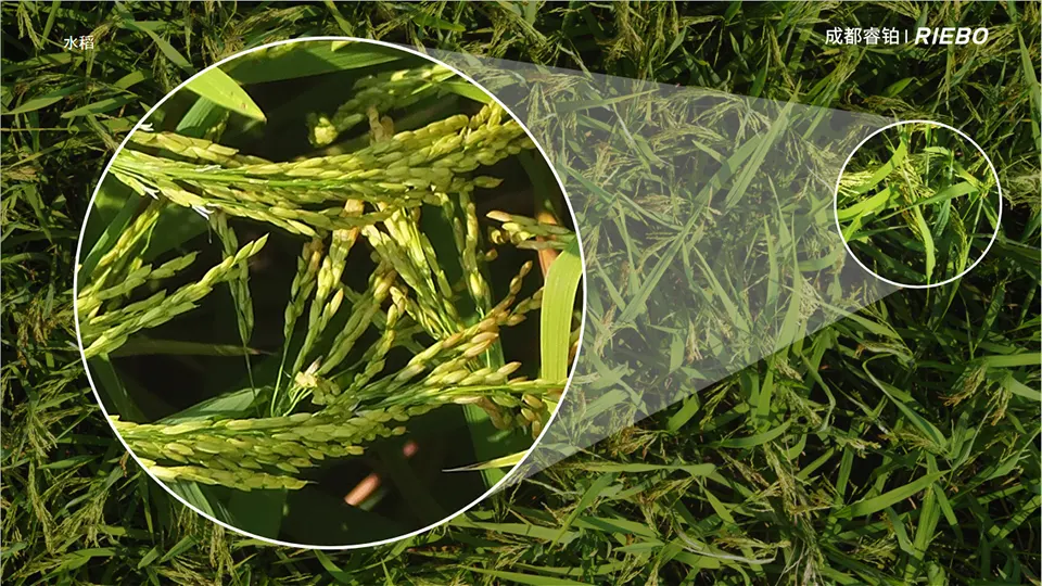
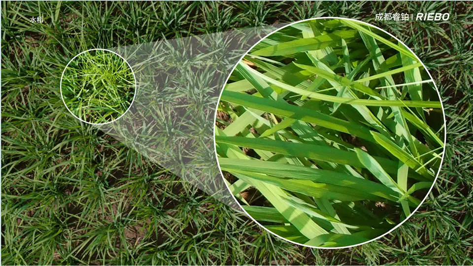
Based on the demand for agricultural high-resolution remote sensing data RuiBao developed a medium format high resolution camera SF10M2, which adopts a medium format image sensor with 120 million pixels of image resolution, and uses RuiBao's self-developed MLE lenses, which are capable of effectively controlling chromatic aberration and controlling the lens aberration to less than three-thousandths of a millimeter. The use of MLS mechanical distortion-free shutter drastically reduces motion distortion. The camera has an ultra-long focal length of 120mm and is capable of capturing aerial image data with a resolution of 0.3mm at an altitude of 10 meters;
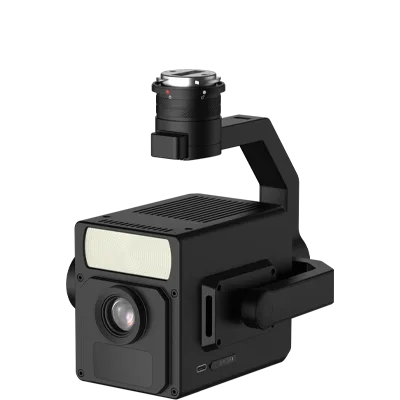
SF10M2 High Resolution Remote Sensing Camera
Professional inspection camera, not only can effectively improve the inspection efficiency, but also can collect ultra-high resolution image data, significantly improve the quality of inspection, for precision agriculture to provide solid and reliable data support.
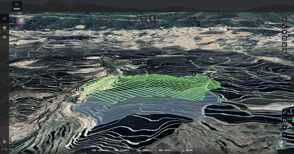
4. Remote sensing route planning software
Aerial Survey and Smart Drawing is a route planning software developed by Ruibao. In addition to supporting the four major types of route planning functions of Ruibao's full series of equipment, namely grid, surround, imitation, and elevation, it also supports the functions of independently importing DEM elevation files and automatically recognizing the type of elevation, as well as the functions of one-key importing of three-dimensional models and automatically aligning with the base map features. With the quick detachable gimbal, it is compatible with various forms of UAV platforms in the market, realizing multi-purpose use and effectively improving operational efficiency. It can be used for large-area, high-precision, complex texture aerial photography, and its unique advantages can be widely used in the fields of smart city, urban planning, inspection and investigation.
Through the route planning software, combined with the positioning system of the UAV, it can realize the autonomous inspection operation of the UAV, greatly reduce the manual intervention, and can perform high-frequency fixed-point rechecking of the key areas or the areas where problems have been found.
It can also realize full-coverage imitation ground inspection of irregular farmland and terraces to ensure the precision of inspection.
5. Development trends
Over the past three decades, China has made great strides in modernizing its agriculture. Agricultural production infrastructure has been comprehensively strengthened, with 800 million mu of high-standard farmland and 1.03 billion mu of effectively irrigated area built. Agricultural production has basically been mechanized, with the comprehensive mechanization rate of major crop cultivation, planting and harvesting reaching 71%, and the total power of agricultural machinery exceeding 1 billion kilowatts. Agricultural science and technology have made significant progress, with the national contribution rate of scientific and technological progress in agriculture exceeding 60 per cent. The utilization rate of chemical fertilizers and pesticides in agricultural production has been significantly increased, the coverage rate of good crop seeds has exceeded 96%, the comprehensive utilization rate of straw has exceeded 86%, and the recycling rate of agricultural films has exceeded 80%. Science and technology have laid a solid foundation for China's food security strategy and comprehensive poverty alleviation.
In the future, automation, intelligence and informationization will become the new development direction of China's agriculture. Precise management of farmland through a digital management platform, automated farm machinery to complete the work of plowing, sowing, harvesting, etc., drones to collect high-definition image data of crops, artificial intelligence combined with big data and other technological means, the growth of crops, pests and diseases to carry out a precise analysis, and then drones to complete the fixed-point application of fertilizers or spraying of pesticides. The whole process will greatly save labor costs, reduce the waste of fertilizer and pesticide pollution of the environment. Provide scientific and technological support to increase agricultural production and farmers' income.
The realization of intelligent, information-based agriculture cannot be separated from the support of massive agricultural data. In particular, high-resolution image data is the basis for artificial intelligence training and big data analysis. Therefore, in the coming period of time, the collection of massive high-resolution image data will certainly become the focus of China's agricultural science and technology development work.