In the wave of urban renewal, land acquisition and compensation surveys serve as a core step that determines both project efficiency and fairness. Traditional surveys rely on manual field measurements, which are not only time- and labor-intensive but also prone to errors and disputes in critical areas such as floor area calculation and building structure records. The integration of oblique photogrammetry cameras and drone technology, with the unique advantage of “3D reality reconstruction,” is reshaping the logic of land acquisition surveys, providing accurate and efficient data support for urban renewal projects.
Breaking Technical Barriers: Why Oblique Photogrammetry Has Become Essential
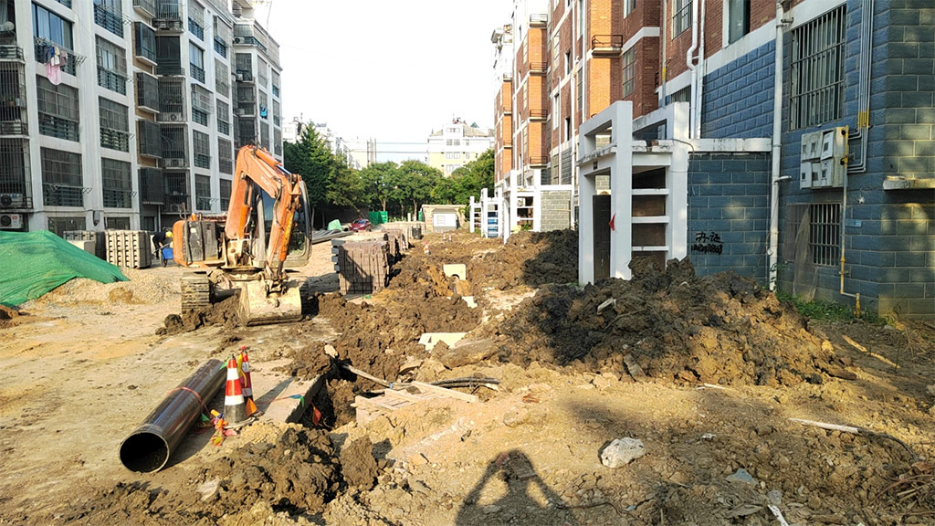
The central requirement of land acquisition and compensation surveys is accurate acquisition of current condition data, including floor area, structural forms, and property boundaries. Old residential areas often face challenges such as high building density, complex layouts, and surrounding obstructions, making it difficult for traditional survey methods to balance efficiency and precision.
Oblique photogrammetry cameras solve these pain points through multi-lens synchronized capture (typically five lenses—front, back, left, right, and nadir). Combined with drone flight paths that generate dense point clouds, they enable rapid reconstruction of 1:1 scale 3D reality models. This “aerial survey + 3D modeling” approach eliminates the safety risks of manual rooftop measurements and overcomes the limitations of 2D imagery in representing building features, allowing every architectural detail to be clearly visualized.
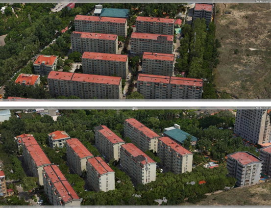
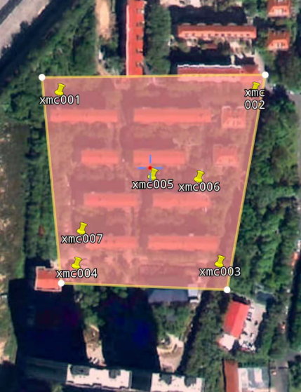
For example, in the Taiyuan Coal Preparation Plant urban renewal project, where densely packed 20–30 meter residential blocks are overshadowed by nearby high-rise buildings, traditional surveying would have required extensive manpower and door-to-door verification. Instead, using oblique photogrammetry, a single drone sortie captured 1,795 high-resolution images, which were processed into a complete 3D model that accurately represented all building structures—providing a reliable basis for subsequent area calculations.
Practical Empowerment: Full-Process Applications from Data to Decision
The value of oblique photogrammetry in land acquisition surveys spans the entire workflow—data collection, model reconstruction, accuracy verification, and decision-making support—upgrading every stage of the traditional process.
Efficient Data Collection: Precision “Scanning” in Complex Environments
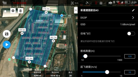
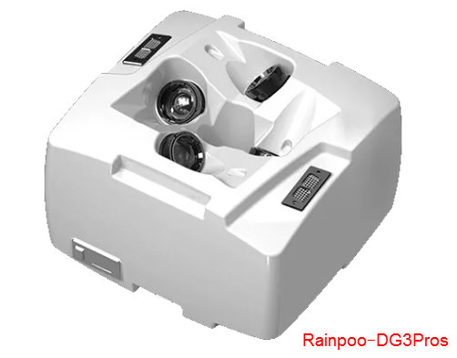
In the Taiyuan project, a DJI M300 drone equipped with the RIEBO DG3pros five-lens oblique camera was deployed. With 50° side angles (left/right) and 45° fore/aft angles, combined with a 120m flight altitude and 80%/75% forward/side overlap, the system ensured complete coverage with zero blind spots.
Flights were conducted between 11 a.m. and 2 p.m. in calm, sunny conditions to maximize image quality. Only five ground control points were used to achieve full coverage of a 0.02 km² survey area, reducing fieldwork time by over 70% compared with traditional methods.
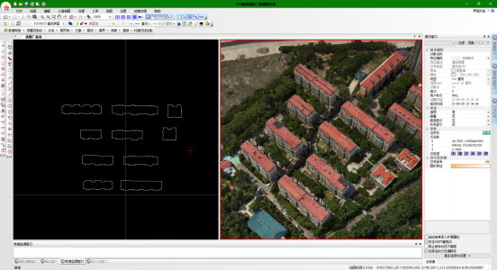
Precision 3D Modeling: Millimeter-Level Reconstruction
Captured imagery was processed in ContextCapture software, completing aerial triangulation in 40 minutes and 3D reconstruction in 18 hours. The resulting model stood out in clarity, completeness, and structural accuracy—clearly presenting balconies, bay windows, and eaves that are often the source of disputes in floor area calculations.
Accuracy is key to usability: in the Taiyuan project, the average plane accuracy reached 0.047m without ground control points, and improved further when controls were added—fully meeting 1:500 cadastral survey standards. This transformed building area calculations from “estimations” into precise measurements, significantly reducing disputes in the compensation process.
Multi-Dimensional Applications: Unlocking the Full Value of 3D Data
3D reality models serve not only as digital archives but also as powerful tools for decision-making:
- Automated floor area calculation: Key corner points can be extracted to automatically compute gross floor area and usable space, eliminating human error.
- Clearer property boundaries: Integrated with cadastral data, the model visualizes property lines for reliable ownership verification.
- Planning visualization: Overlaying renovation schemes on the 3D model shows spatial changes pre- and post-renovation, improving communication with stakeholders.
- Efficient emergency response: Models can store structural and utility distribution data, supporting safer construction management.
Reconstructing Value: Boosting Both Efficiency and Fairness
The adoption of oblique photogrammetry is more than a technical upgrade—it redefines the logic of land acquisition surveys, achieving efficiency gains and fairness assurance.
- Efficiency: In the Taiyuan case, what once required two weeks of fieldwork and processing was compressed into just three days, with outputs directly integrated into real estate survey systems—streamlining workflows and accelerating project timelines.
- Fairness: The objectivity of 3D models acts as a neutral referee. Models can be archived for permanent reference, ensuring transparency in compensation standards. Residents can also view their own property data within the model, strengthening trust in the process.
Conclusion: Technology Driving the Future of Urban Renewal
The Taiyuan Coal Plant project illustrates how oblique photogrammetry cameras have become a standard tool in land acquisition surveys. By combining aerial perspectives, 3D modeling, and precise measurement, they resolve the long-standing issues of low efficiency, poor accuracy, and frequent disputes in traditional methods.
Looking ahead, with the integration of AI defect recognition and BIM-based collaborative management, oblique photogrammetry data will evolve from static archives into dynamic management platforms, providing comprehensive and intelligent support for urban renewal.
In the era of high-quality urban development, these spatial measurement technologies not only enhance government service efficiency but also embody fairness and transparency in city governance—bringing a human touch of technology to community redevelopment projects.


