In today’s rapidly developing geospatial industry, urban 3D reality modeling and rural land registration projects have become two major application areas. The former, exemplified by Qingdao’s 1.79 billion RMB 3D modeling project, drives the development of smart cities, while the latter focuses on clarifying rural property rights, directly affecting farmers’ livelihoods.

Although both belong to the field of geoinformation applications, they differ significantly in technical standards, operational environments, and equipment requirements. Confusing the two approaches may lead to equipment safety risks and compromised data quality.
Technical Standards: From “Property-Oriented” to “Model-Oriented”
Technical regulations are the foundation of project execution, and the two types of projects follow entirely different standards due to their distinct objectives.
- Rural land registration projects focus on clarifying property ownership. All technical requirements revolve around real estate registration. These projects must strictly follow the Real Estate Registration Database Standards (Trial) and the Guidelines for Rural Real Estate Survey Work, emphasizing cadastral survey accuracy, ownership investigation procedures, and data formatting. For example, in homestead surveys, accurate documentation of property boundaries, land area, and land-use type is critical to ensure legal validity for compensation and property transfer.
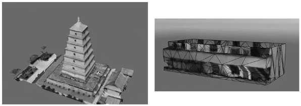
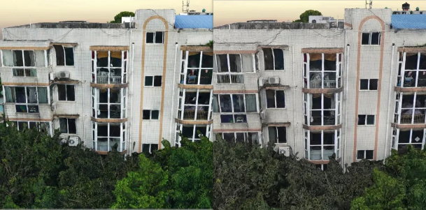
- Urban 3D reality modeling projects focus on building high-precision spatial models. According to the Urban 3D Modeling Technical Specifications, projects must classify and grade models (LOD1–LOD4) covering terrain, buildings, and transportation facilities. For instance, terrain models progress from basic DEM to high-precision DEM + DOM; building models evolve from simple block shapes to detailed models with windows and balconies; transport infrastructure is modeled from road centerlines to fully detailed environments with streetlights and traffic signs. This tiered system supports both large-scale urban planning and fine-grained smart city management.
Work Environments: Rural “Low Interference + Dispersed” vs. Urban “High Complexity + High Density”
The work environment directly affects project execution, and differences are evident across terrain, surface features, and climate.
- Rural projects are characterized by low interference and high dispersion. Advantages include fewer tall structures, limited reflective surfaces, stable lighting, and clear air quality. However, challenges include scattered villages requiring frequent UAV take-offs, vegetation movement affecting feature matching, and sudden weather changes in mountainous areas.
- Urban projects face highly complex and dense environments. UAVs are affected by electromagnetic interference, reflective surfaces like glass facades, and turbulent wind conditions caused by high-rise structures. Dust and low-altitude airspace restrictions further complicate operations. For example, in commercial areas, flight windows may be reduced due to crowd density or sudden airspace restrictions.
Hardware Requirements: From “Basic Adaptation” to “Precision Customization”
Hardware performance is key to ensuring data quality, with major differences in cameras and UAV configurations.
- Camera focal length:
- Rural projects can use standard 25mm–35mm cameras, as UAV altitude is typically under 100m, ensuring sufficient resolution for cadastral accuracy (≤0.016m).
- Urban projects must resolve the “altitude vs. precision” dilemma. With taller buildings requiring higher flight altitudes, long focal length or full-frame cameras are essential to maintain resolution (~0.03m) while capturing detailed textures.
- Operational efficiency:
- Rural projects face fewer time pressures, though frequent UAV take-offs increase power consumption.
- Urban projects demand high-efficiency and rapid response. Larger CMOS sensors expand coverage per flight, shorter exposure intervals (as low as 0.6s) improve overlap, and swappable storage modules reduce data transfer times from 30 minutes to 5 minutes.
- Model quality:
- Rural projects prioritize accuracy for legal certainty, requiring centimeter-level precision but not detailed visual effects.
- Urban projects emphasize both accuracy and visual quality to support smart city applications such as traffic management and urban planning visualization. High-resolution, color-accurate cameras with anti-reflective coatings are essential to ensure realistic textures and clear details.
Conclusion
Although both urban 3D reality modeling and rural land registration projects fall under the geoinformation sector, their differences in technical standards, environmental conditions, and equipment requirements are substantial. Only by understanding these distinctions and tailoring workflows accordingly can project quality and efficiency be ensured, maximizing their role in smart city development and rural property rights reform.