Rural land surveys form the foundation for clarifying property ownership and safeguarding farmers’ rights. However, challenges such as wide survey coverage, scattered land features, and the low efficiency of manual measurements have long constrained progress. In traditional surveys, ground control point (GCP) deployment is time-consuming and labor-intensive, while data accuracy is vulnerable to terrain and human error. With its core advantage of high-precision modeling without GCPs, oblique photogrammetry is becoming the key technology to address these pain points—offering efficient and precise solutions for rural land surveys.
Technical Adaptation: Why Oblique Photogrammetry Fits Rural Survey Needs
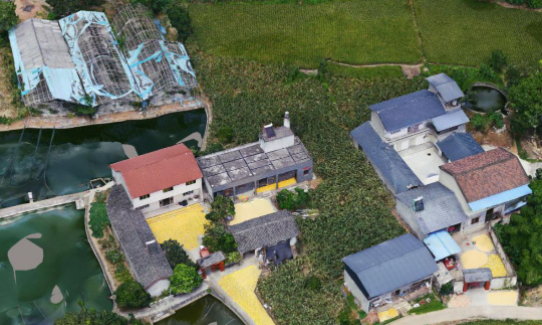
The primary requirement of rural property surveys is the efficient acquisition of accurate spatial data, including house dimensions, boundary lines, and terrain features. Unlike urban areas, rural survey sites are characterized by small-scale houses (1–3 floors), dispersed distribution, and the presence of farmland, woods, and ponds. Although terrain variation is relatively modest (generally under 15 meters), traditional manual surveying requires point-by-point validation, which is both labor-intensive and prone to data gaps due to obstructions.
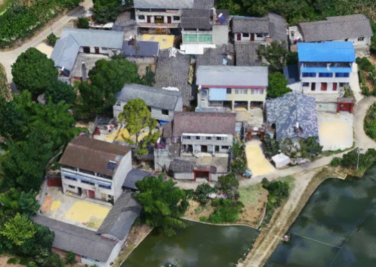
Oblique photogrammetry addresses these challenges through multi-lens image capture and 3D reconstruction. Using a five-lens camera to simultaneously capture roof and façade images, drones generate dense point clouds that enable rapid reconstruction of true-to-scale 3D reality models. This ensures comprehensive restoration of dispersed houses and complex land features. More importantly, the “no-GCP” technology significantly reduces the need for extensive ground control work, making it ideal for rural areas with vast coverage and limited accessibility.
A rural project in Deyang, Sichuan Province demonstrated this adaptability. Covering 0.2 km² with diverse land types, traditional methods required dozens of GCPs and over a week to complete. With oblique photogrammetry, a single drone flight captured all data, and no-GCP modeling accuracy fully met survey standards.
Practical Implementation: Full Workflow from Flight to 3D Modeling
The value of oblique photogrammetry in rural land surveys extends across the entire workflow—equipment selection, flight planning, data processing, and accuracy verification—with each step optimized for rural conditions.
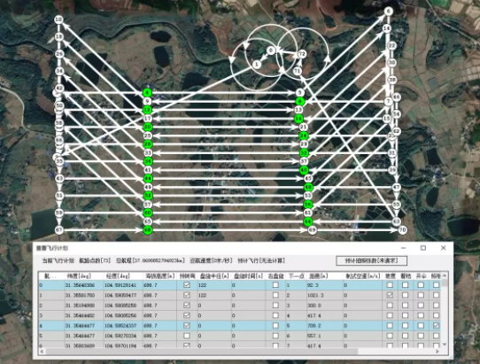
1. Equipment and Flight Planning: Efficient Data Capture in Complex Environments
Rural survey areas demand high drone stability and fast camera response. In the Deyang project, the team deployed a CW10 VTOL fixed-wing drone paired with the RIEBO DG4pros five-lens oblique camera, forming a high-efficiency data acquisition system.
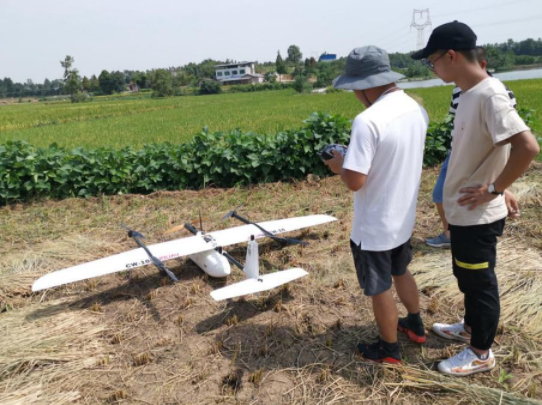
The DG4pros camera, the market’s only full-frame device with a 0.6-second exposure interval, is perfectly suited to high-speed fixed-wing flights. At a designed speed of 18 m/s (peaking at 25 m/s under wind influence), it consistently captured sharp images. With 80% forward overlap, 75% side overlap, and 2 cm ground resolution, plus a 100m buffer for edge coverage, the drone completed a 0.45 km² flight in just 35 minutes, acquiring 3,000 high-quality images in a single sortie.
Pre-flight preparations included selecting open terrain for safe takeoff/landing and clearing obstacles such as power lines. Post-flight checks confirmed imagery quality and integrity, meeting photogrammetry standards for 3D modeling.
2. Data Processing: Intelligent Optimization for Higher Efficiency
Wide-area rural flights often produce redundant data, increasing processing time. The team employed a “pre-processing + redundancy filtering” workflow:
- SkyScanner software handled data segmentation, renaming, and attitude solutions, outputting files compatible with ContextCapture.
- SkyFilter removed low-value images (e.g., wide turns), eliminating 51.6% of images and reducing the dataset from 3,000 to 1,451 effective images.
This optimization reduced aerotriangulation time from 2h 47m to just 31m, saving over two hours while minimizing data layering risks. Final results showed a reprojection RMS error below 0.5 pixels, ensuring robust modeling accuracy.
3. Accuracy Verification: No-GCP Mode Meets Survey Standards
Rural surveys require controlled relative error, typically ≤10 cm. To validate no-GCP feasibility, the team set up 11 checkpoints for comparison between GCP-based and GCP-free models, cross-verifying with on-site tape and laser measurements.
Sample results:
| House ID | Field Measurement (m) | With GCP (m) | No GCP (m) | Error (With GCP) | Error (No GCP) |
| 1 | 7.21 | 7.18 | 7.18 | 0.03 | 0.03 |
| 2 | 7.01 | 6.92 | 6.88 | 0.09 | 0.13 |
| 3 | 1.82 | 1.79 | 1.76 | 0.03 | 0.06 |
Results showed mean errors of 0.0363 m with GCPs and 0.0418 m without GCPs, both well within the 10 cm requirement. This proves that oblique photogrammetry can achieve survey-grade precision even without GCPs, significantly reducing field workload.
Value Innovation: Dual Gains in Efficiency and Quality
The adoption of oblique photogrammetry is not just a tool upgrade but a systemic transformation of rural land surveys, delivering improvements in efficiency, accuracy, and cost.
- Efficiency: In traditional surveys, GCP deployment alone accounts for over 40% of total project time. In Deyang, no-GCP technology compressed fieldwork from multi-day GCP setup + house-to-house measurement to one drone flight + minimal verification, shortening the cycle by over 60%.
- Accuracy: Full-frame imaging and smart modeling deliver clear details of building edges, balconies, and corners, reducing errors caused by visual limitations or obstructions. DG4pros’ chromatic aberration correction and distortion calibration further ensure geometric fidelity, supporting objective property boundary delineation.
- Cost: By eliminating most GCP setup, reducing flight sorties, and automating data processing, oblique photogrammetry cuts overall survey costs by 30–50% compared with traditional methods.
Outlook: Improving Technology for Wider Rural Applications
Despite strong results, further refinement is needed for large-scale rural surveys. The Deyang test area was only 0.2 km²; larger areas may require additional validation of long-term accuracy stability in no-GCP mode. Model quality can also be affected by adverse weather (wind, haze), causing minor distortions at building edges.
However, advancements such as DG4pros’ 210-megapixel resolution, low-dispersion optics, and improved algorithms are steadily overcoming these challenges. Future integration with AI recognition could automate property boundary extraction and ownership labeling, making rural land surveys even smarter.
Conclusion: Technology Empowering Modern Rural Governance
The Deyang case shows that oblique photogrammetry has become a powerful tool for rural land surveys. Its high-precision, no-GCP capability solves many bottlenecks of traditional methods. In the context of rural revitalization and land rights reform, this technology not only improves efficiency and accuracy but also supports property registration, land acquisition, and homestead management with reliable data—helping modernize rural governance systems.


