In drone-based oblique photogrammetry and 3D reality modeling, vegetation—especially trees—has long been considered one of the most difficult elements to reconstruct accurately. Unlike buildings and infrastructure with clear geometric structures, trees present irregular shapes, dense foliage, and dynamic movement, making them challenging for photogrammetry algorithms.
In many projects, tree modeling issues often manifest as blurred textures, missing trunks, distorted branches, or fused vegetation clusters. In addition to affecting visual quality, dense vegetation areas can significantly slow down 3D reconstruction workflows and reduce overall modeling efficiency.
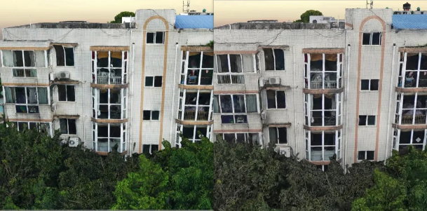
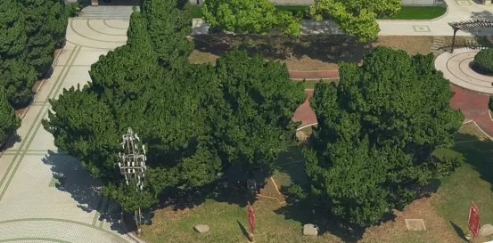 Leaves are stuck together and blurred
This article explains why tree modeling is difficult in oblique photogrammetry and introduces three practical solutions to improve vegetation modeling quality.
Common Problems in Tree Modeling
Poor Model Quality
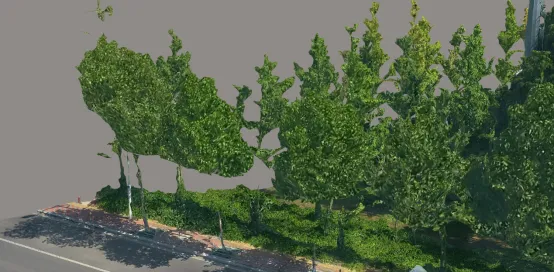 Missing leaves
In aerial photogrammetry projects, vegetation areas such as trees, shrubs, lawns, and gardens often appear with:
- Blurred textures
- Fused leaves and branches
- Missing trunks
- Distorted geometry
- Incomplete reconstruction
Unlike buildings with stable edges and surfaces, tree structures lack consistent geometric features, which makes it difficult for algorithms to reconstruct accurate 3D models.
Slow Modeling Speed
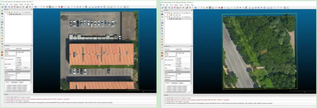 Select house blocks and tree blocks of the same size on the same model
Another challenge associated with tree modeling is processing speed. Dense vegetation generates a significantly larger number of mesh faces, which increases reconstruction time.
In one test case, using identical tile sizes and computing resources:
- A building block generated approximately 276,137 faces and took about 25 minutes to process
- A tree-dense block generated approximately 1,216,896 faces and took about 48 minutes to process
This example shows that tree areas can produce more than four times the number of faces while nearly doubling processing time, significantly affecting project efficiency.
Why Tree Modeling Is Difficult
Complex Natural Structures
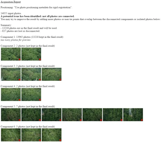 Trees did not participate in the blank three matching
Trees exist in complex natural environments and have irregular geometric structures. Leaves, branches, and trunks vary in size, orientation, and density, making feature extraction difficult.
Additionally, many aerial cameras are designed using general photography components rather than optimized photogrammetry hardware. As a result, captured images may contain insufficient feature points, which leads to poor reconstruction quality.
When processing large forest areas, some images may fail to participate in aerial triangulation, further degrading model accuracy.
Algorithm Limitations
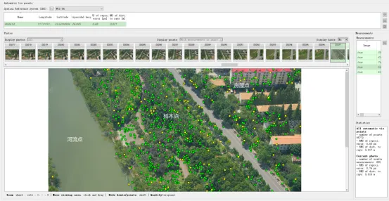 Comparison of house points, tree points and river points
Another major factor is the limitation of feature-matching algorithms.
Most photogrammetry software, such as ContextCapture, uses feature-based matching algorithms like SIFT (Scale-Invariant Feature Transform). These algorithms identify feature points such as:
- Corners
- Edges
- Distinct texture areas
However, trees often lack stable feature points. Leaves may move between exposures due to wind, causing mismatches between images. This leads to blurred or melted-looking tree models.
Unlike trees, surfaces such as water bodies contain almost no feature points, which may result in complete model holes rather than blurred reconstruction.
3 Effective Solutions for Improving Tree Modeling
1. Use Cameras That Capture More Feature Points
Increasing the number of available feature points significantly improves modeling quality. High-performance oblique cameras designed for aerial photogrammetry can capture clearer textures and generate more reliable feature points.
Better feature extraction leads to:
- Reduced model gaps
- Improved texture clarity
- More accurate tree structures
This hardware-based improvement is often the most direct way to enhance vegetation modeling performance.
2. Post-Processing Model Enhancement
Another practical approach is model enhancement during post-processing.
For example, software such as SVS MeshEditor allows users to create vegetation libraries by collecting tree models from existing 3D scenes or external resources. These tree models can then be batch-planted into 3D environments.
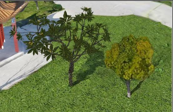 SVS MeshEditor creates a tree model library and implements batch planting
This method is not limited to trees. It can also be applied to:
- Grass
- Water surfaces
- Landscape elements
- Urban vegetation
Once created, the model library can be reused across multiple projects, improving efficiency and consistency.
3. Independent High-Quality Vegetation Modeling
For projects requiring extremely high visual realism, independent vegetation modeling may be used.
This approach involves:
- Capturing detailed tree images
- Creating high-quality tree models using software such as Blender or Maya
- Importing models into 3D scenes
- Placing vegetation manually
This workflow is more complex but produces highly realistic 3D environments suitable for digital twin cities, gaming environments, or simulation projects.
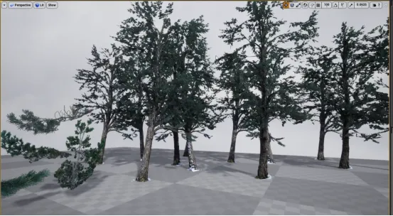 UE4 creates realistic tree scenes
How Riebo’s Oblique Photogrammetry Solutions Improve Vegetation Modeling
Riebo’s drone mapping cameras and oblique photogrammetry systems are designed specifically for aerial modeling applications. By optimizing multi-angle imaging, image quality, and synchronization, Riebo solutions improve feature extraction in complex environments such as vegetation areas.
Combined with advanced processing workflows, Riebo solutions help users:
- Improve vegetation modeling accuracy
- Reduce reconstruction time
- Minimize model gaps
- Enhance 3D realism
These advantages make Riebo’s photogrammetry systems suitable for smart city modeling, infrastructure mapping, and digital twin applications.
Conclusion
Tree modeling remains one of the most challenging aspects of oblique photogrammetry due to irregular geometry, environmental complexity, and algorithm limitations. However, by combining improved hardware, post-processing enhancement, and independent modeling techniques, users can significantly improve vegetation modeling results.
With advanced imaging systems and optimized workflows, Riebo continues to help professionals achieve more accurate, efficient, and visually realistic 3D models across a wide range of applications.