In the field of environmental restoration, accurately capturing topography and landform information is the foundation for all subsequent work. Traditional surveying methods often struggle with low efficiency, limited accuracy, and a lack of intuitive data presentation, especially in complex terrains. The emergence of oblique photography technology has revolutionized ecological restoration projects, showing significant advantages in areas such as abandoned mines and degraded industrial land. This article explores the application value and practical pathways of oblique photography technology in environmental restoration through real-world cases.
Technology Empowerment: Solving Surveying Challenges in Environmental Restoration
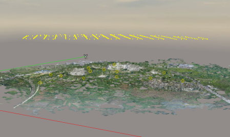
Oblique photography integrates multiple cameras mounted on UAVs to capture images from different angles, which are then processed into high-precision, photorealistic 3D models. Unlike traditional nadir aerial photography that only provides vertical imagery, oblique photography offers multi-angle and stereoscopic perspectives of the restoration area, delivering accurate spatial data to support project planning and execution.
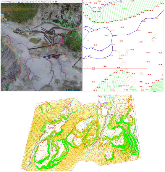
For instance, in the Chaohu Lake abandoned mine ecological restoration project, the terrain was extremely steep with cliffs, escarpments, and long-term water accumulation at the bottom. In some areas, elevation differences exceeded 200 meters, making conventional surveying nearly impossible. The project team deployed a DJI Matrice M600PRO UAV equipped with a Riebo DG4Pros oblique five-lens mapping camera (210MP total resolution, 42MP per lens). The system captured fine surface textures while offering long endurance (14 km range, 28 minutes flight time), ensuring efficient image acquisition even in rugged terrain.
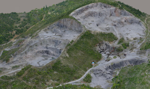
During aerial surveys, flight parameters were carefully designed: altitude 220 m, ground sampling distance (GSD) 2.5 cm, 80% forward overlap, and 70% side overlap. To ensure model completeness, the capture area extended 150 m beyond the boundary. In total, 65 sorties were flown, producing 185,600 images with uniform clarity and color—providing a solid foundation for high-accuracy modeling.
Data-Driven Insights: High-Precision Outputs Supporting Restoration Design
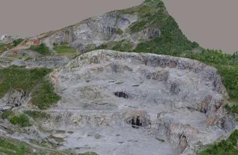
The true value of oblique photography lies not only in rapid image acquisition but also in the generation of high-precision deliverables, including 3D reality models, large-scale topographic maps, and orthophotos. These outputs serve as critical references for restoration planning, construction guidance, and post-project evaluation.
In this project, quality control software (SKY Scanner by Riebo) was first used to check image completeness. Redundant photos were filtered using SKY Filter, and attitude correction was applied through AAC software. For 3D modeling, Smart3D was run on a high-performance workstation cluster (Intel i9-10980XE, 256 GB RAM, RTX 2080Ti GPUs), efficiently generating photorealistic 3D models.
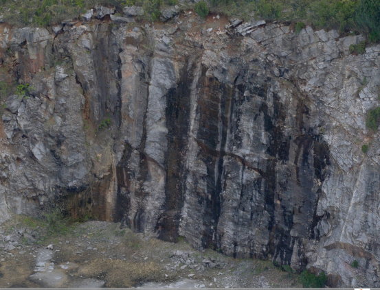
Subsequently, 1:500 topographic maps were produced in CASS 3D, and orthophotos in Pix4D. Accuracy tests confirmed maximum planimetric error of 0.103 m and elevation error of 0.783 m, meeting the stringent requirements of ecological restoration projects. The 3D models vividly represented cliffs, waterlogged zones, and elevation variations, enabling engineers to precisely plan slope cutting, soil covering, and vegetation planting—avoiding costly design deviations caused by inaccurate data.
Practice Expansion: Multi-Technology Integration for Complex Scenarios
While oblique photography excels in open terrains, its performance may be limited in areas with dense vegetation or severe occlusion. To overcome this, project teams integrate complementary technologies such as LiDAR point clouds and RTK digital surveying, ensuring full coverage and accuracy in complex environments.
For Chaohu Lake, two heavily vegetated mine zones unsuitable for oblique photography were surveyed with a hybrid approach. LiDAR point clouds penetrated canopy gaps to capture terrain geometry, while RTK provided precise measurements of key features. The combined dataset ensured seamless topographic coverage across the project area.
This multi-technology fusion approach is widely adaptable. In wetland restoration, oblique photography can be paired with bathymetric surveys to capture both terrestrial and underwater terrain. In heavy-metal contaminated sites, photorealistic 3D models can be integrated with soil sampling data to visualize pollutant dispersion and guide remediation planning.
Future Outlook: Driving Intelligent and Data-Driven Restoration
With ongoing advances in AI, big data, and sensor miniaturization, oblique photography will play an even greater role in environmental restoration. In the future, UAV-captured 3D reality models can be fused with environmental monitoring data (e.g., air, water, and soil quality) to build dynamic ecological monitoring systems for real-time tracking and evaluation.
For example, vegetation growth areas can be marked within the 3D model and linked with UAV-based multispectral monitoring to automatically analyze survival rates and detect degradation. By comparing multi-stage 3D models and monitoring datasets, big data analytics can evaluate restoration effectiveness and optimize project strategies.
Additionally, integration with BIM (Building Information Modeling) will enable digital management across the entire lifecycle of restoration projects. During design, BIM models can be aligned with 3D terrain data for accurate plan-to-site matching. During construction, UAV oblique photography can monitor progress and compare it against BIM schedules. During maintenance, a digital archive can be created to support long-term ecological management.
Conclusion
With its efficiency, precision, and intuitive visualization, oblique photography technology has become an indispensable tool for environmental restoration. The Chaohu Lake case study demonstrated its ability to tackle surveying challenges in rugged terrain, deliver high-quality data for restoration design, and integrate with other technologies for diverse scenarios.
Looking ahead, as innovation continues, oblique photography will drive environmental restoration toward greater intelligence, precision, and sustainability, making significant contributions to ecological improvement and sustainable development worldwide.


