Compared with traditional surveying and mapping, drone aerial surveying features short operation cycles, low costs, and wide applicability, serving as an effective supplement to the traditional surveying industry. However, in certain areas with large terrain height differences, oblique photographic cameras cannot uniformly plan all aerial survey tasks; instead, different solutions must be applied based on specific scenarios.
RIEBOtech has summarized key considerations for aerial surveys in typical urban high-rise areas and high-altitude difference mountainous terrains, aiming to help clients reduce operational risks, save costs, and improve efficiency.
I. Data Collection in Urban High-Rise Areas
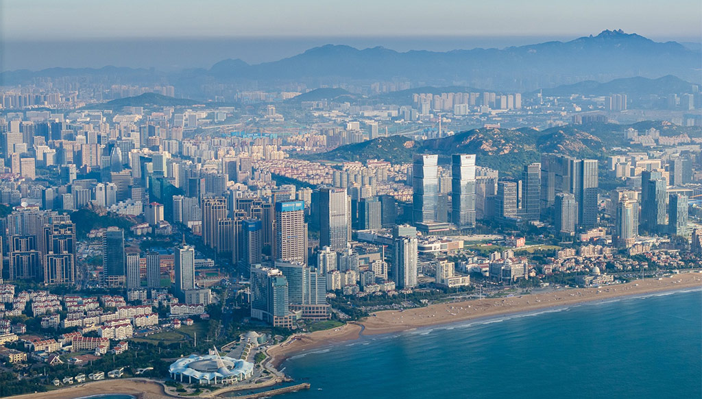
With the upcoming launch of the "3D Real-Scene China" project, smart city construction projects will also see growth, making 3D modeling of urban high-rises (over 100 meters) an unavoidable task. While oblique photography technology performs well in cadastral surveying projects in rural areas with generally low-rise buildings, it faces significant challenges in high-rise urban regions.
1. Difficulties in Modeling High-Rise Aerial Surveys
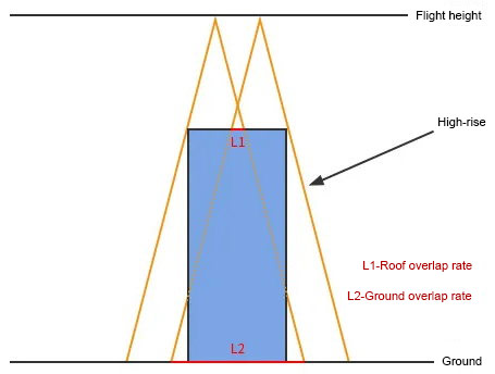
Given current technological levels, modeling difficulty increases with building height. Firstly, high-rises raise operational risks, increasing the probability of drones colliding with buildings or losing control and causing injuries. Secondly, as building height increases, the overlap rate of upper parts of high-rises drops sharply, resulting in severe graffiti and voids on the model roof.
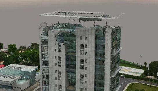
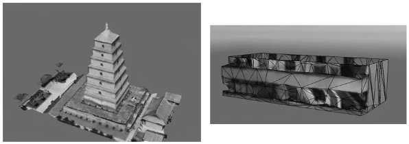
△ Modeling effect of a 100-meter-high building
2. Solutions for High-Rise Aerial Surveys
Generally, a camera’s field of view is determined by sensor size and focal length. For aerial survey cameras, the field of view is fixed: the farther the camera is from the subject, the more content it captures; the closer it is, the narrower the shooting range.
In urban operations, due to excessive building height, the overlap rate between the upper areas of high-rises and the ground differs significantly. The taller the building, the more severe the insufficient overlap rate, and the higher the probability of holes, blurring, or distortion on the model’s top.
To address the impact of high-rises on overlap rates, the following methods can be adopted:
2.1 Increase Flight Overlap Rate
Flying with a high overlap rate ensures the actual overlap rate of building tops, making this method suitable for areas with dense high-rises. In general, more overlapping images captured during aerial photography mean richer spatial and texture information, resulting in better modeling effects. For high-rises, moderately increasing the overlap rate significantly improves model quality.
However, excessively high lateral overlap rates sharply reduce the efficiency of field data collection and indoor data processing, while increasing the risk of issues like aerial triangulation stratification. Therefore, clients are advised to reasonably increase the flight overlap rate based on actual conditions.
2.2 Partial Supplementary Flying
For areas with few high-rises, most operations follow an 80% forward overlap rate and 70% lateral overlap rate. Supplementary flying can be conducted separately for high-rises with insufficient overlap rates afterward.
2.3 Increase Camera Focal Length
Under the same resolution and overlap rate, a long-focal-length lens can enhance the actual overlap rate of building tops and ensure a sufficiently safe flight height, achieving better modeling effects for high-rises.
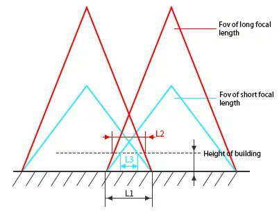
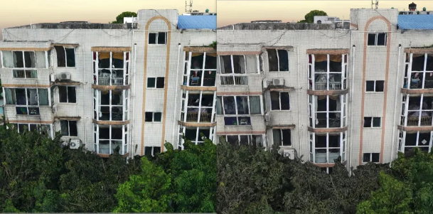
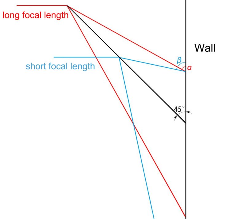
However, RIEBOtek’s R&D team found in experiments that data and image information collected by long-focal-length lenses exhibited severe blurring under building eaves during modeling. This is because, with the same ground resolution, a longer focal length requires a higher flight altitude, leading to more blind spots under the eaves. As shown in the figure, compared with short-focal-length lenses, long-focal-length lenses have more obstructed views.
Thus, for oblique photography, simply pursuing longer or shorter focal lengths is not advisable. Focal length is closely related to model quality and flight efficiency, and there is a certain contradictory relationship between flight altitude and modeling effects. Considering these factors comprehensively, RIEBOtek developed the DG3 and Pros series oblique photographic cameras, which ensure high model quality while balancing flight altitude and improving operational efficiency.
II. Mountainous Area Aerial Surveys
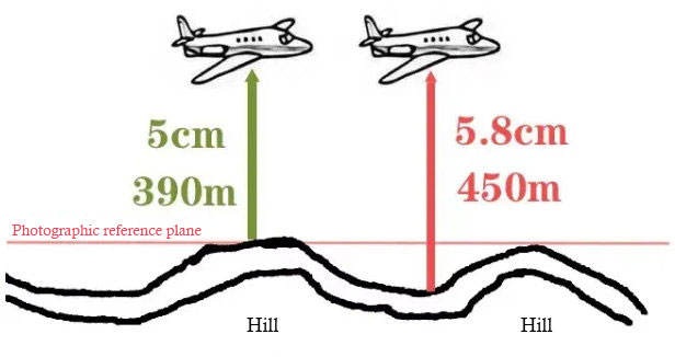
Data collection and modeling in high-altitude difference mountainous areas are equally challenging, especially in regions with large terrain undulations like Yunnan, Guizhou, and Sichuan, where conventional operation methods struggle to meet project requirements.
1. Difficulties in Mountainous Area Aerial Surveys
Due to large height differences in mountainous areas, a single flight altitude cannot satisfy both overlap rate and resolution requirements. This often results in high overlap rates but low resolution in lower-lying areas, and low overlap rates but high resolution in higher areas, leading to issues like aerial triangulation stratification during data processing or poor modeling effects.
2. Solutions for Mountainous Area Aerial Surveys
To avoid these problems, the following flight methods are generally adopted for mountainous areas:
2.1 Layered Flight
In regions with large height differences, a single flight altitude cannot meet modeling requirements. Instead, layered flight following mountain undulations is used to ensure the aircraft maintains a consistent height relative to the mountain as much as possible. Note the following points:
If a single-layer route is short, you can complete one route, pause, and upload the next route without re-taking off and landing, saving battery power.
For layered routes, adjust the return altitude appropriately before switching routes each time.
2.2 Terrain-Following Flight
Import the Digital Elevation Model (DEM) file of the survey area into the ground station, and generate routes that follow ground undulations for aerial modeling (this method is mostly used for multi-rotor drones).
However, terrain-following flight requires importing a DEM, setting waypoints, and a preliminary flight, which increases operation time and workload compared to layered flight. Additionally, terrain-following flight cannot effectively avoid high-altitude hazards like high-voltage lines. In practice, some clients have experienced drone collisions with high-voltage lines or base stations due to poor route planning. Thus, clients are advised to use terrain-following flight reasonably based on actual conditions.
2.3 Close-Range Photogrammetry
In some mountainous areas with excessive height differences and steep slopes, where layered flight and terrain-following flight are ineffective, facade scanning with drones can effectively solve facade measurement problems in such regions. In July this year, RIEBOtek released the M6Pros surveying camera, a RIE series product mainly used for close-range photogrammetry.
Its close-range photogrammetry results are highly demonstrative, achieving excellent outcomes in dangerous rock mass surveys (see case: "Academician Team and M6Pros: Close-Range Photogrammetry Practice on the Yangtze River Cliffs") and ancient building modeling (see case: "Introduction to the Digital Application Case of Xi'an Ancient City Wall").