1. Project Background
To implement national strategic requirements for rural land certification and cadastral registration — including unified registration of residential homesteads and collective construction land — Salt Lake District of Yuncheng City (Shanxi Province, China) initiated a comprehensive rural property rights surveying and modeling project.
The project included:
- Rural property rights investigation
- 1:500 topographic mapping
- Oblique photogrammetric surveying
- 3D reality modeling
- Development of a property registration and certification system
This initiative aims to support rural land governance, legal property ownership, and digital cadastral infrastructure.
2. Client Overview
Stellar Space (Tianjin) Technology Development Co., Ltd. — a certified geospatial data service provider — served as the implementing partner. The company holds multiple qualifications including first-class surveying and mapping accreditation and advanced GIS system integration capabilities.
Their core services include:
- Aerial LiDAR and UAV photogrammetry
- Mobile and terrestrial laser scanning
- 4D products and spatial databases
- 3D digital city and rural information systems
- Geo-information software development
The firm’s expertise supports surveying and mapping needs across infrastructure, urban planning, emergency response, utilities oversight, and natural resource management.
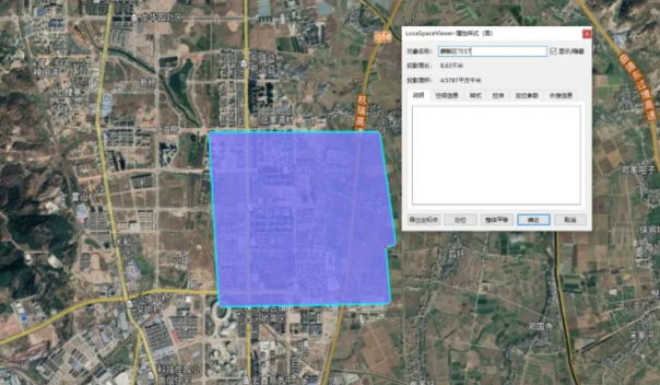
3. Survey Area
The project covers Salt Lake District, located in southwestern Shanxi Province at the junction of Shanxi, Henan, and Shaanxi provinces.
- Total area: ~1237 km²
- Includes 19 towns and 287 administrative villages
- Survey domain comprises tens of thousands of rural parcels totaling ~100 km²
The area’s scale posed significant logistical and data volume challenges.
4. Equipment & Technical Setup
To capture high-precision imagery efficiently across a large rural territory, two UAV + oblique photogrammetry systems were deployed:
- DJI M300 RTK with Riebo D2 PSDK oblique camera
- DJI M600 Pro with Riebo DG3 Pros multi-lens oblique camera

High-performance computing clusters with NVIDIA GPU acceleration (2080Ti / 3080) and large memory capacity supported the data processing workflow.
5. Flight Mission and Data Capture
Flight operations used conventional cadastral photogrammetric parameters:
- Planned flight altitude aligned with 1:500 mapping standards
- Forward and side image overlap maintained at high percentages
- UAV flight lines primarily oriented north–south
- RTK positioning used for accurate image control
- Millions of aerial photos were acquired, producing a dense dataset for model reconstruction
Image quality was ensured through consistent exposure and overlap design.
6. Data Processing Workflow
Workflow included:
➤ Positional Data Preprocessing:
RTK GPS landmarks and distinct ground features (e.g., zebra crossings, road mark signs, L-shaped targets) were measured to provide precise control and validation checkpoints.
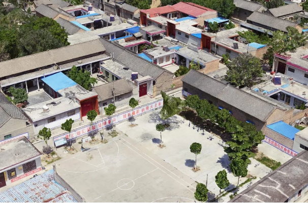
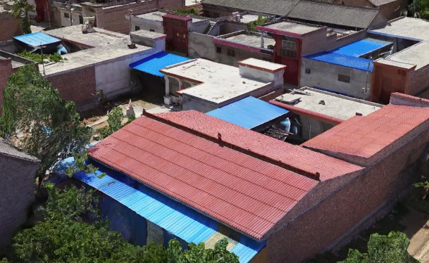
➤ Oblique Model Generation:
Photogrammetric reconstruction was performed using ContextCapture and M3D aerial triangulation tools. All blocks were processed with unified origin and consistent tiling parameters to guarantee model coherence across the large area.
➤ Model Management & Storage:
Processed outputs were organized with unique block identifiers to facilitate search, retrieval, and subsequent integration into cadastral systems.
7. Key Findings and Quality Review
Although the full project was still in progress, intermediate model evaluations showed:
✔ Model precision and accuracy exceeded 95% benchmark compliance
✔ Models generated with DG3 Pros cameras exhibited slightly higher detail compared with D2 cameras under similar conditions
✔ Local issues such as terrain variation and weather conditions occasionally affected overlap or visibility
Overall, the imagery and modeling quality met the accuracy requirements for cadastral mapping and 3D reconstruction.
8. Application and Impact
The 3D reality models produced by this workflow have been used to:
- Generate cadastral base maps
- Assist field survey and verification
- Build geospatial databases for rural land management
These spatial products provide a digital foundation for property registration, legal documentation, and system integration in rural cadastral management.
9. Summary and Best Practices
This large-scale oblique photogrammetry project demonstrated several operational insights:
- Riebo oblique cameras delivered high operational stability and imaging quality — the M300 with D2 camera was capable of single-operator missions with minimal faults.
- Preprocessing with automatic invalid photo removal improved workflow efficiency and increased aerial triangulation success rates.
- Standardized data block organization ensured seamless model integration and improved model retrieval and reuse.
Finally, the integration of UAV photogrammetry into cadastral surveying workflows significantly reduced labor intensity, improved mapping accuracy, and enhanced data processing efficiency, supporting digital rural land governance.