In urban planning, land management, and smart city development, cadastral surveys are the foundation for acquiring core information such as land ownership, boundaries, and area. The accuracy of these results directly determines the scientific validity and legality of subsequent decisions. Traditional cadastral surveys rely heavily on manual fieldwork, which is inefficient and difficult to execute in densely built-up urban areas with complex signal environments.
The advent of the RIEBO mapping camera, built on oblique photogrammetry technology, offers a solution defined by high precision, high efficiency, and strong adaptability. A prime example is the 1:500-scale cadastral survey project in Fanshi County’s urban district, where the RIEBO DG4Pros oblique photogrammetry camera overcame key challenges and accelerated the transition of cadastral surveys toward digitalization and intelligent management.
Core Challenges of Urban Cadastral Surveys
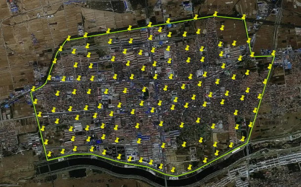
The Fanshi project covered about 7.5 km². While the terrain was relatively flat (elevation differences ≤30 m), it included a wide range of land features: from single-story houses and 5–6-story residential buildings to 20–26-story high-rises up to 70 m tall, along with farmland, grassland, and roads.
Three major challenges emerged:
- Stringent accuracy requirements: At a 1:500 scale, surveys demand extremely high ground sampling distance (GSD) and positional accuracy to capture building corners, road edges, and boundary lines with precision.
- Complex interference: Dense mobile towers and radio signals in urban environments disrupt UAV control, while frequent strong winds in northern China affect flight stability and image quality.
- Efficiency vs. safety: Narrow streets, heavy traffic, and crowded conditions complicate the placement of ground control points (GCPs). Large-area data collection had to be completed within tight timeframes while minimizing site disruptions.
Traditional surveying struggled to balance these demands. The RIEBO DG4Pros, with its “five-lens synchronized capture, full-frame high-resolution imaging, and environmental adaptability,” became the key equipment for solving these problems.
RIEBO DG4Pros: A High-Precision Tool for Urban Cadastral Surveys
As one of the most advanced full-frame oblique photogrammetry cameras, the DG4Pros is designed specifically to meet the rigorous demands of cadastral mapping.
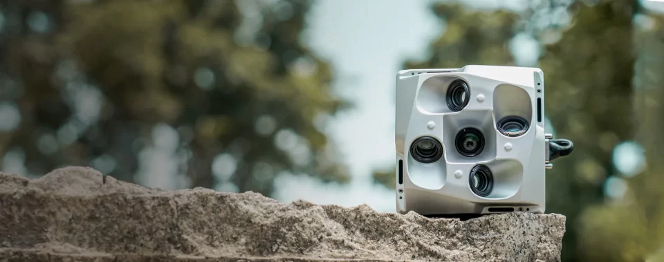
1. Hardware Excellence: Precision and Efficiency
- Five-lens layout: One nadir + four oblique lenses with advanced optical design, minimizing distortion to less than 0.4% and enhancing edge sharpness—essential for accurately capturing building rooftops and façades.
- Ultra-high resolution: With over 225 megapixels total and 42 MP per lens, paired with a 36×24 mm CMOS sensor, it achieves a ground resolution (GSD) of 1.45 cm—exceeding the detail required for 1:500-scale cadastral surveys.
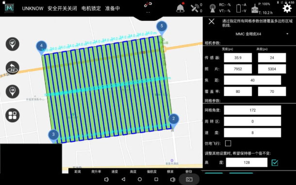
- Operational efficiency: Minimum exposure interval of 0.6s, synchronized exposure modes, 640 GB onboard storage, and USB3.0 transfer speeds of 160–240 MB/s. In Fanshi, just 24 flights captured 198,560 high-quality images across 9 km² (including buffer areas), each mission lasting up to 55 minutes.
- Lightweight and stable: Weighing only 960 g, the DG4Pros easily integrates with industrial UAVs such as the M6 hexacopter. Built-in cooling, dust-proofing, and capture feedback ensure stable operations even in windy conditions.
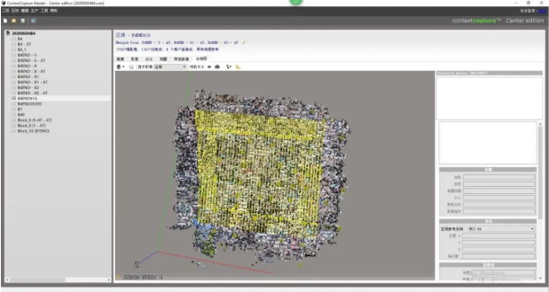
2. Streamlined Data Processing
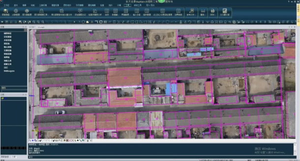
High-quality imagery must be paired with efficient processing. RIEBO’s SkyScanner v6.1.3 preprocessing software provided an all-in-one solution, including redundant photo removal, pose calculation, and aerial triangulation.
In Fanshi, SkyScanner processed 137 ground checkpoints and 60 building corner checkpoints, delivering standardized datasets for modeling. Combined with the MapMatrix3D photogrammetry system, the workflow generated accurate DLG (digital line graphs) with positional errors well below regulatory limits, meeting all 1:500 cadastral requirements. Internal processing time was cut by more than 30%.
From Cadastral Surveys to Smart City Applications
The high-precision 3D models and cadastral data from the DG4Pros deliver value far beyond land registration:
- Cadastral applications: Legally valid basis for land ownership, leasing, and transfer; reliable data for tax assessment, land grading, and transparent revenue collection; and spatial references for planning, redevelopment, and environmental protection.
- Smart city integration: Reality-based 3D data serves as a public information backbone for urban management, law enforcement, tourism, and heritage preservation. Illegal buildings can be quickly identified, evacuation routes planned, and historic sites digitally archived.
Industry Significance: Driving Surveying Innovation under Policy Momentum
China’s “Reality-Based 3D China” initiative, a priority in the 14th Five-Year Plan for national surveying, positions oblique photogrammetry and 3D urban mapping as billion-level market opportunities. The Fanshi project demonstrates the viability of the DG4Pros in dense urban environments and provides a replicable high-precision cadastral survey solution for the industry.
Compared with traditional surveying, the RIEBO solution reduced safety risks, tripled efficiency, and transformed cadastral outputs from abstract 2D drawings into intuitive 3D reality models. This shift makes data more transparent, actionable, and accessible to governments, enterprises, and citizens.
Conclusion
The Fanshi County project proves that the RIEBO DG4Pros oblique photogrammetry camera is a core tool for modern urban cadastral surveys. Its high-resolution imaging, robust adaptability, and efficient data workflows overcome urban challenges such as dense buildings, signal interference, and adverse weather. Beyond cadastral registration, the results extend to smart city governance and digital land management.
As China accelerates its 3D spatial infrastructure, RIEBO’s oblique photogrammetry technology will continue to empower land management, urban planning, and smart city development—driving the digital transformation of the geospatial industry.


