In traditional land acquisition and demolition projects, evaluations often rely on 2D drawings or conventional surveying methods. These approaches suffer from outdated information, limited visualization, and difficulties in data integration—making it challenging to meet the demands of modern infrastructure projects for efficient and precise land acquisition management. With the rapid development of drone-based oblique photogrammetry technology, this situation has been significantly improved.
A prime example is the Huize–Qiaojia (Huíqiǎo) Expressway planning and construction project. By introducing the RIEBO mapping camera, the project team built a high-precision 3D reality model and established a digital management platform. This innovation brought new vitality to land acquisition and demolition workflows, enabling a leap forward from “traditional rough management” to “digital precision governance.”
Technical Breakthrough: RIEBO Mapping Cameras Overcoming Complex Terrain Challenges
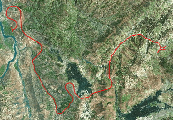
The Huíqiǎo Expressway project area, located in western Huize County, Qujing City, Yunnan Province, presents extremely complex terrain conditions. Elevation spans from 880 to 2,860 meters and covers diverse features including villages, forests, farmland, rivers, and cliffs. Frequent strong winds further increase the difficulty of aerial data collection. Traditional surveying methods are inefficient and unable to capture detailed terrain information comprehensively. The application of the RIEBO mapping camera became the key to overcoming these challenges.
For this project, the flagship RIEBO DG4 Pros oblique photogrammetry camera was deployed. It offers multiple advantages for complex environments:
- A parallel lens layout with a 40mm nadir lens and 56mm oblique lenses, achieving a total resolution of 225 megapixels.
- Ground sampling resolution of 1.5–3 cm, ensuring clear capture of densely built-up areas and steep terrains.
- The 40mm nadir lens supports high-resolution imaging while allowing higher flight altitudes, which—when paired with the DJI M600Pro drone platform—helped mitigate the risks posed by strong winds and significantly improved operational efficiency and safety.
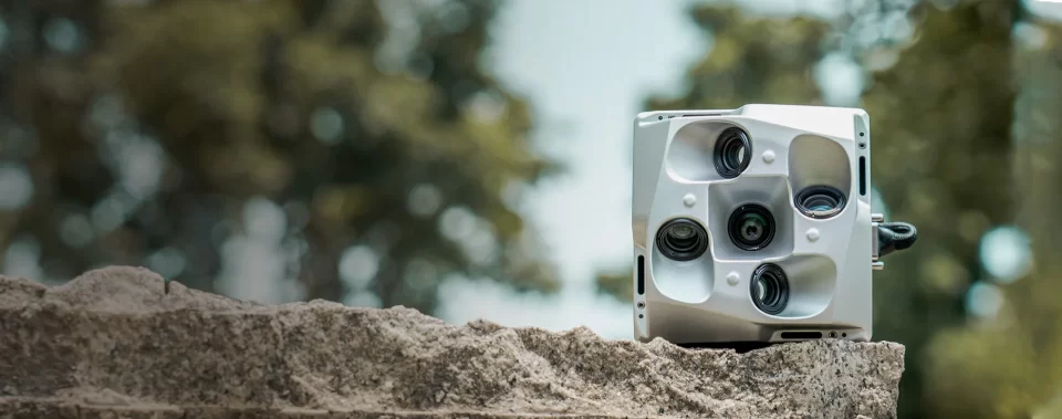
Additionally, the DG4 Pros supports unified UAV power supply, synchronized/interval exposure, and ultra-fast data transfer speeds of up to 300 Mb/s. Its optimized PPK (Post-Processed Kinematic) workflow reduced the number of ground control points (only 135 GCPs and 73 checkpoints were used). During data processing, RIEBO SkyScanner preprocessing software and UAV-PPK tools ensured quality checks, differential calculations, and efficient 3D model generation. The final 3D model achieved a planimetric error of just 0.042 m and vertical error of 0.053 m—fully meeting the strict accuracy requirements of land acquisition assessment.
Real-World Application: 3D Reality Models Driving Full-Process Digital Land Acquisition
Using high-precision 3D models generated by the RIEBO camera, the project team built a digital land acquisition and demolition management platform, seamlessly integrated with Yunnan Province’s geological big data system. This enabled oblique photogrammetry and reality modeling to be embedded into every step of the acquisition process, forming a fully digitalized workflow from data collection – analysis and evaluation – decision-making – compensation settlement.
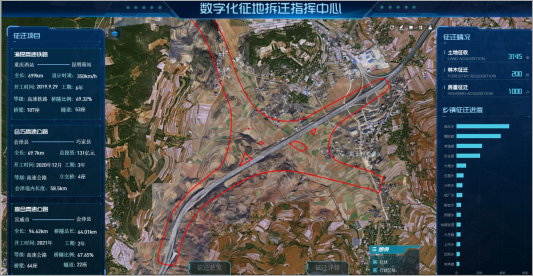
- Data Collection & Monitoring: The platform integrates 250+ datasets, including terrain vectors, land-use survey maps, and multi-temporal imagery. Staff could visualize 2D/3D features, monitor village layouts, forestry distribution, and housing structures, and lock in the baseline conditions of surface assets—effectively preventing illegal last-minute planting or construction.
- Compensation Evaluation & Decision-Making: Combining geological big data resources with on-site checks, staff could perform accurate measurement and valuation of land, trees, and buildings within 3D scenes. The platform’s digital command center provided real-time progress dashboards for land area, forestry relocation, and township completion ratios—solving long-standing problems of information asymmetry and low coordination efficiency.
- Compensation Settlement: A one-stop process centralized all data, evaluation results, and compensation standards. This streamlined workflow reduced human error, improved efficiency, and ensured transparency, minimizing disputes while accelerating project land acquisition.
Industry Value: Oblique Photogrammetry Redefining Land Acquisition Management
The Huíqiǎo Expressway project demonstrates how oblique photogrammetry and drone mapping cameras can transform land acquisition management.
- Efficiency Gains: Traditional methods require intensive manpower for field surveys and drawings. With RIEBO solutions, 170,506 qualified images were captured across a 75 km corridor with 3–5x higher efficiency, while digital workflows cut evaluation and scheduling time by over 40%.
- Accuracy and Fairness: 1.5–3 cm resolution and millimeter-level modeling errors ensure reliable measurements, preventing disputes caused by survey deviations. The 3D reality model also enabled traceable, transparent evaluation processes—protecting the rights of affected residents and enhancing government credibility.
- Future Outlook: This project proves the reliability of drone-based oblique photogrammetry in complex terrain. As technologies like GIS, BIM, and big data continue to integrate with RIEBO’s photogrammetry systems, applications in urban renewal, infrastructure development, and rural revitalization will continue to expand—driving smarter, more precise land resource management in China.
The Huíqiǎo Expressway case highlights that RIEBO mapping cameras and oblique photogrammetry are not merely technical upgrades but a core engine for digital land acquisition management. They shift workflows from experience-driven to data-driven and from rough administration to precise governance, providing a solid foundation for modern infrastructure and smart governance.


