As the flagship product of Riebo Technology, the DG4 Pros oblique photography camera fully deserves its reputation as a top-tier oblique camera with its exceptional hardware and software configurations. With its support, clients can tackle numerous projects that were previously extremely challenging to implement due to equipment and technical limitations.
This time, the Institute of Economic Management Science of the Ministry of Natural Resources (Heilongjiang Institute of Surveying and Mapping Science) utilized the Riebo DG4 Pros camera paired with the DJI M600 Pro multi-rotor UAV to complete a 1:500 cadastral accuracy true 3D modeling project in a certain area of Shantou City. Some buildings in the survey area reach nearly 110 meters, with the tallest exceeding 180 meters. Ensuring the model's quality and accuracy under such conditions was the greatest challenge throughout the project! Below is an introduction to the project implementation process and the application of subsequent results compiled by the team.
Project Background
The achievements of the "integrated multi-survey" project have a wide range of applications. Based on the needs of regional planning and construction in Shantou City, this project is jointly undertaken by the Institute of Economic Management Science of the Ministry of Natural Resources and the Shantou Institute of Surveying and Mapping. Its core tasks include the production of oblique photogrammetry-based models, the construction and application of relevant topographic maps, and the development and application of a natural resources big data platform centered on natural resources information.
The project aims to carry out high-precision oblique aerial photography in the main urban area of Shantou, achieving high-precision real 3D modeling, 1:500 topographic mapping, and completion survey through a single aerial photography campaign.
Survey Area Introduction
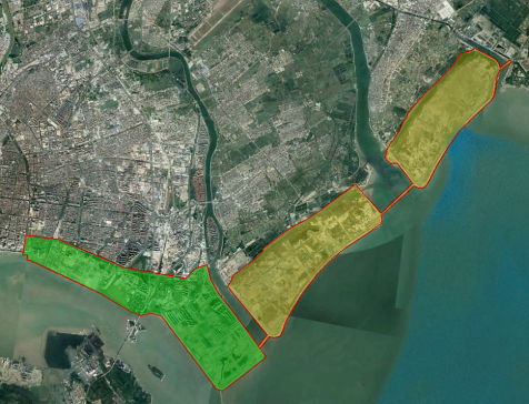
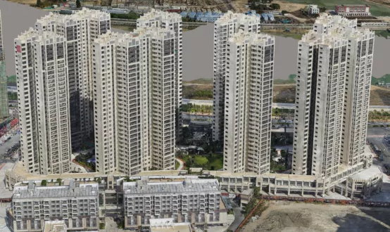
The survey area is located in a region of Shantou City, Guangdong Province, dominated by a delta alluvial plain with a topographic height difference of less than 10 meters. It features a mix of mid-rise and high-rise buildings: mid-rise buildings range from 20 to 30 meters, high-rise buildings are below 110 meters, and some construction areas exceed 180 meters. Surface features include sandy land, construction sites, and coastal areas, making it a developing region.
UAV Operation Conditions
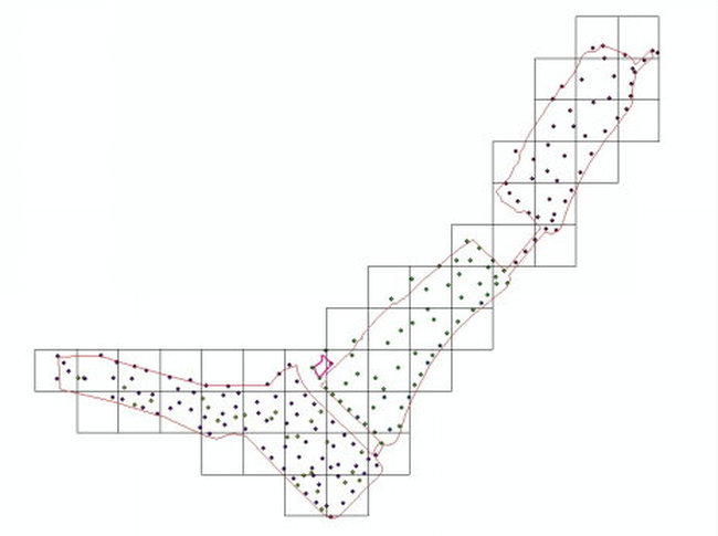
UAV operations were conducted from 9:00 AM to 3:00 PM. During this period, the survey area experienced clear weather with moderate light, occasional thin clouds, and a gentle breeze of level 1-2, which is suitable for flight. The survey area was equipped with 8-12 ground control points (GCPs) per square kilometer on average, along with a total of 45 ground and building corner checkpoints to meet project production requirements.
Equipment Selection
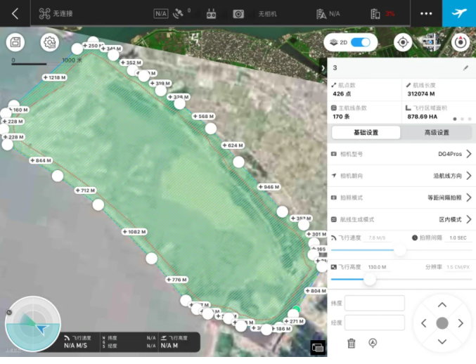
To ensure precision in UAV-based oblique photography, 1:500 topographic mapping, and cadastral mapping, the aerial photography ground sampling distance (GSD) must meet the rigid requirement of 1.5cm-1.7cm. Considering the high-rise characteristics of the project area, we selected the DJI Matrice M600 Pro UAV equipped with the Riebo DG4 Pros five-lens oblique camera.
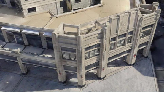
The DG4 Pros oblique camera features a longer focal length than most conventional oblique cameras on the market, enabling the UAV to fly at a sufficiently safe altitude while maintaining a ground resolution of less than 2cm. Additionally, its full-frame lenses capture more angles of buildings during flight in high-density high-rise areas, thereby maximizing model quality.
Aerial Photography Parameter Design
- Flying Altitude: 130 meters (adjusted to 260 meters for high-rise areas)
- Ground Sampling Distance (GSD): 1.5cm
- Forward/Side Overlap: 80%/75%
- Effective Survey Area: Approximately 27 km²
- Actual Aerial Photography Area: Approximately 33 km²
- Total Flight Sorties: 179
- Flight Speed: 7.8 m/s (considering the impact of sea breezes)
- Single Sortie Duration: About 25 minutes
- Total Images Captured: 445,055 (clear images with uniform colors, meeting project requirements)
Data Processing
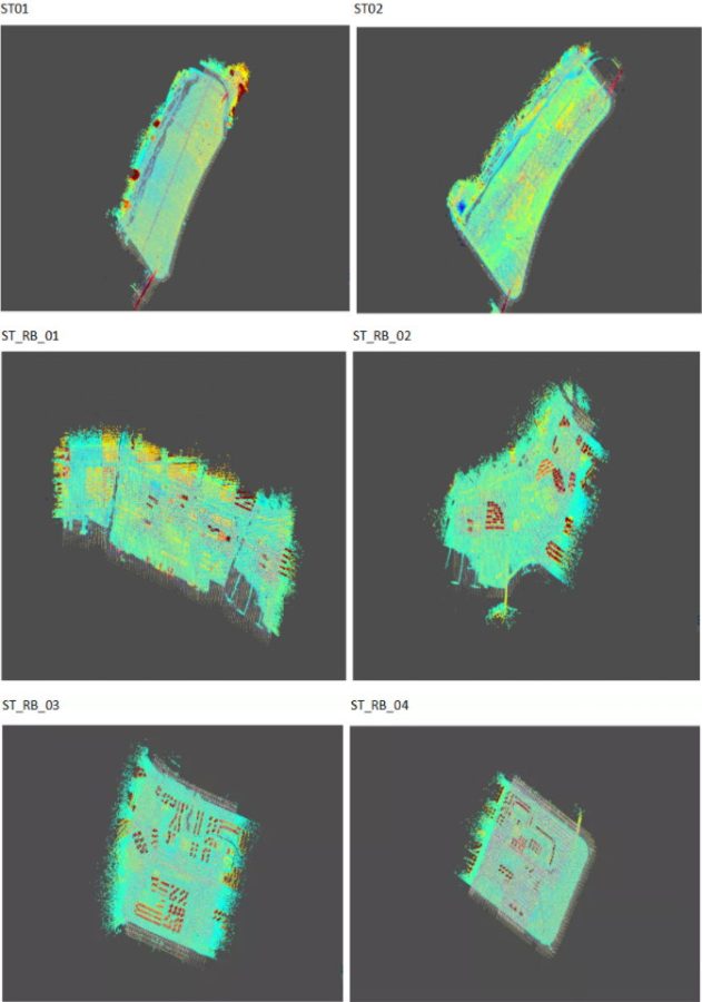
1. Aerotriangulation
Aerotriangulation was processed using Mirauge3D software with 10 nodes. The graphics workstation was configured with an Intel Xeon Silver CPU, 64GB RAM, and an NVIDIA P4000 graphics card. The 445,055 images were divided into 6 zones for production.
Area Network Adjustment Results
- Total Runtime: 24,539.597 seconds
- Image Point Reprojection Error: Mean = -0.002003, 0.839344, 0.018840; RMSE = 0.811094
- Number of Control Points: 48
- Control Point Residuals: Mean = -0.000266, 0.000399, -0.000824; RMSE = 0.007944, 0.010215, 0.004444; Max = -0.021711, 0.032253, -0.016775
- Number of Check Points: 5
- Check Point Residuals: Mean = 0.014353, 0.007268, -0.062379; RMSE = 0.026000, 0.014657, 0.066774; Max = 0.048232, 0.025637, -0.091922
2. DLG Production
Based on the aerotriangulation and model results, 1:500 topographic mapping was conducted using DP Modeler 2.0 software, and orthophotos were generated with SVS. Both products met the project's precision requirements after inspection.
Mapping Precision Analysis
A total of 45 precision verification points were used. The final model's horizontal root mean square error (RMSE) was 0.04 meters, meeting the project's precision requirements. Key indicators:
- Percentage of points with errors less than 1x designed RMSE: 100.00%
- Percentage of points with errors between 1x and 2x designed RMSE: 0.00%
- Percentage of points with errors greater than 2x designed RMSE: 0.00%
Project Application
The project's outcomes serve as the base map for constructing Shantou's Natural Resources Big Data Platform, with the following core applications:
- Dynamic Clipping & Logical Monetization: Using vector ranges collected from 3D models to achieve dynamic clipping of 3D models and logical monetization combined with vector information, meeting refined management requirements.
- Comprehensive Data Management: Integrating real 3D data, high-precision terrain data, orthophotos, territorial spatial planning data, CAD topographic maps, completion data, and cadastral data for unified management.
- Scheme Comparison & Progress Monitoring: Comparing designed BIM schemes with actual 3D scenes to support scheme evaluation and progress monitoring of major projects, fulfilling the needs of natural resources monitoring and territorial spatial planning implementation supervision.
- 3D Integrated Management: Combining above-ground real 3D models with underground pipelines to construct a "3D Unified Map" of urban natural resources, enabling comprehensive above-ground and underground management and services.
Project Summary
For urban-scale 3D reconstruction, UAVs typically fly at low altitudes and use multi-lens systems to collect data, resulting in massive image datasets. This poses challenges for aerotriangulation adjustment, especially when processing large image zones or areas with significant elevation differences between sorties.
However, the Riebo-calibrated survey-grade high-resolution lenses deliver stable shooting and high-quality images, ensuring a high pass rate during area network adjustment of large zones with 100,000+ images—free from layering or massive image loss. Additionally, the adjustment speed and mapping precision are excellent, shortening indoor processing cycles while meeting diverse project requirements.
The stability and high image quality of Riebo lenses provide certainty for the production timeline of urban-scale oblique photography projects, playing a crucial role in ensuring project schedules and improving operational efficiency. The achievements and experience from the Shantou project can be further applied to projects such as rural housing surveys, completion drawing measurements, and basic surveying and mapping data updates.
Institutional Introduction
The Institute of Economic Management Science of the Ministry of Natural Resources (Heilongjiang Institute of Surveying and Mapping Science) is affiliated with the Heilongjiang Administration of Surveying, Mapping, and Geoinformation. It serves as the Chairman Unit of the China Oblique Photogrammetry Technology Alliance and hosts the Heilongjiang Provincial Academician Workstation for "Key Technology Research on Internet + Geoinformation".
The institute has over 70 on-the-job employees, including 8 registered surveyors and more than 20 senior engineers. It holds independent legal person status and Class A surveying and mapping qualifications, equipped with a series of advanced domestic and foreign surveying and mapping hardware and software, such as Street Factory, Pixel Factory, and mobile road measurement systems.
In recent years, the institute has adopted effective measures including innovation-driven development, talent strengthening, transformation and upgrading, and industry-university-research cooperation. It has formed a research and business development pattern centered on geographical national conditions monitoring, digital city and smart city construction, and related application system development, with distinctive features in integrated multi-plan spatial planning and oblique photogrammetry technology application.
The institute has completed over 300 national and provincial-level scientific research projects, as well as smart city and digital city construction projects. More than 30 achievements have won national and provincial awards, establishing it as a leading surveying and mapping research institution providing high-quality geoinformation services for government management, decision-making, and industry applications.


