In response to national and provincial initiatives to advance rural property registration and cadastral management, Hubei Zhicun Aerial Survey Technology Co., Ltd. engaged Riebo’s drone and oblique photogrammetry technology for a large-scale rural land and house rights registration project. The goal was to produce accurate, high-resolution spatial data for rural cadastral surveying, mapping, and rights documentation.
Client Profile
Hubei Zhicun Aerial Survey Technology Co., Ltd. is a high-tech enterprise specializing in aerial surveying, photogrammetry, remote sensing, and GIS solutions. The company offers end-to-end services including airspace approval, aerial data capture, processing, and practical results applications across land planning, utilities, transportation, and natural resource sectors.
Survey Area Characteristics
- Terrain varied from plains to hills with elevation difference of 10–400 m, complex landforms, and diverse building structures (low to high-rise).
- Local climate featured abundant sunlight and suitable flying winds (< 5 m/s), enabling reliable drone operations during morning and afternoon periods.
Technology & Equipment Used
For this project, the survey team selected the DJI M300 RTK UAV equipped with the Riebo M6 Pros photogrammetry camera, integrated with network RTK correction to perform a large-area control-free aerial survey.

Key Equipment Features:
✔ High-accuracy RTK positioning for spatial precision
✔ Large-format, stabilized lens system for consistent image quality
✔ Efficient data capture enabling large area coverage per flight
Flight Mission & Data Acquisition
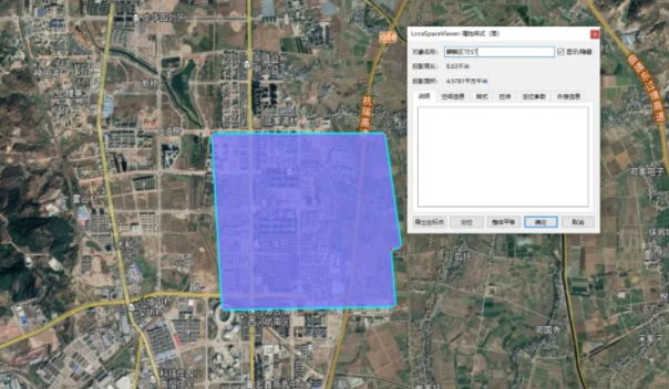
- Survey area: ~130 km² effective region; ~187 km² actual flight coverage
- Flight strategy:
- Plains: Regionally zoned circular flight patterns at ~120 m altitude
- Hilly terrain: Terrain-adaptive flight with altitude correction
- Image capture parameters:
- Ground sampling distance (GSD): 1.5 cm
- Overlap: 50%
- Duration: One month of aerial operations with five UAV teams in rotation
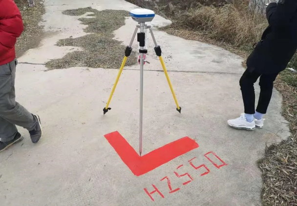
- Control points: Distinct surface features (e.g., road markings, crosswalks, L-shaped targets) measured with RTK for accuracy checks
All collected aerial images were clear and uniformly illuminated, ensuring quality imagery for modeling and cadastral use.
Data Processing Workflow
Once aerial imagery was collected, the internal processing pipeline included:
- Aerial Triangulation & Calibration — using Agisoft PhotoScan (Metashape)
- Point Cloud & Mesh Generation — imported into CloudCompare for 3D model reconstruction
- Model Optimization — tiling outputs (~30–60 min per grid) with mesh and texture refinement
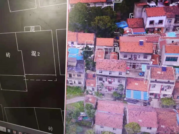
- DLG (Digital Line Graphic) Production — leveraging PSG and EPS tools to produce topological outputs
- Accuracy Validation — comparing model coordinates vs. field-measured checkpoints using CORS RTK
Model Accuracy Verification
To verify geometric accuracy against ground truth:
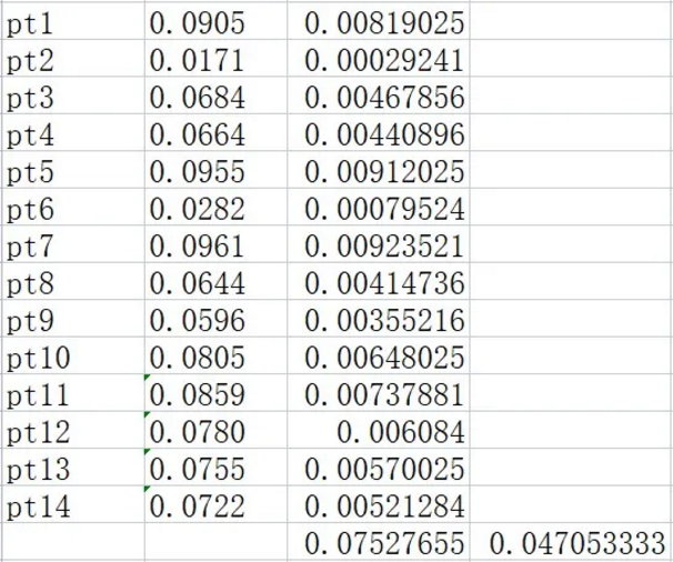
- 23 field checkpoints were measured
- 14 control points for building corner features were used for comparison
- Results:
- Maximum planar error: 9.61 cm
- Minimum planar error: 1.71 cm
- Root mean square (RMS) error: ~4.7 cm
- These precision results satisfy the 1:500 cadastral mapping accuracy standard, confirming that Riebo’s data and workflow fully support cadastral and rights registration requirements.
Project Deliverables
Outputs delivered included:
- High-resolution aerial imagery with uniform exposure
- Accurate 3D reconstruction of rural terrain and structures
- DLG and digital map products ready for cadastral integration
- Verified coordinate data for land parcels and house boundary features
Application & Impact
The case unified rural land and housing survey efforts with standardized spatial references and data formats — establishing a “three-in-one” cadastral results framework:
✔ Unified spatial reference system
✔ Consistent data topology and formats
✔ Aligned application standard for land, house, and rights documentation
This integrated data now supports rural land registration, property rights issuance, and long-term spatial management.
Project Summary & Best Practices
- The selected single-lens regional circumnavigation flight strategy reduced data volume by ~66% compared with traditional five-lens systems.
- This approach significantly reduced flight time and processing cost while ensuring quality deliverables.
- Planning and approval of controlled airspace were essential to maintain compliance with national UAV regulations.
- Riebo’s UAV photogrammetry solution outperformed traditional cadastral survey methods in efficiency, cost, and visual modeling capacity.