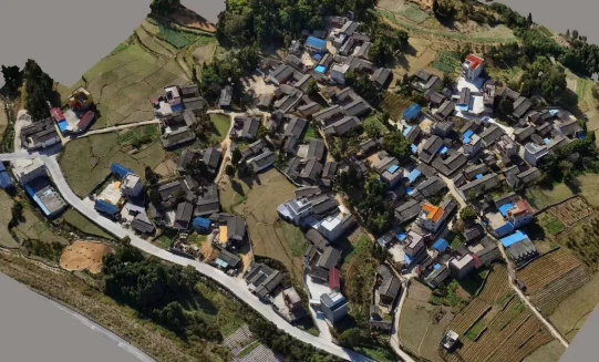
In the field of oblique photogrammetry, nearly 70% of cameras are used in surveying applications, among which cadastral mapping holds a particularly large share. For example, one client in Heilongjiang alone completed a 1,000 km² cadastral mapping project using Riebo cameras.
While oblique photogrammetry has long demonstrated outstanding results in rural cadastral surveying, it has faced significant challenges in urban high-rise areas due to equipment limitations. To overcome these issues, Riebo introduced the DG4Pros oblique photogrammetry solution—designed specifically for precise, safe, and efficient mapping in dense, vertical environments.
Today, we’ll take the Zhejiang Provincial Surveying and Mapping Brigade project as an example to demonstrate DG4Pros’ real-world performance in high-rise cadastral modeling.
1. Project Background: A Persistent Challenge in High-Rise Cadastral Surveying
After years of development, oblique photogrammetry has evolved from “questionable accuracy” to “mainstream adoption” in rural mapping. However, urban high-rise areas, with their large elevation differences and dense building layouts, remain a tough environment for traditional equipment.
Key Limitations of Conventional Systems
- Inadequate lens parameters: Standard oblique cameras often have insufficient focal length, small image sensors, and poor distortion control—making it difficult to meet 1:500 accuracy standards.
- Safety vs. precision conflict: Achieving a ground resolution ≤2 cm typically requires flying at 70–100 m altitude, which is unsafe and often insufficient to capture rooftops of 100 m tall buildings, resulting in poor overlap and high operational risks.
Project Goal
In May 2019, the Zhejiang Surveying and Mapping Brigade collaborated with Riebo Technology to test whether DG4Pros could achieve planimetric accuracy ≤5 cm after data collection and modeling—meeting the 1:500 cadastral mapping standard.
2. Project Execution: Precision Control from Equipment to Flight Planning
Given the project area’s average building height of 100 meters, high density, and complex rooftops, the team prioritized safety, accuracy, and efficiency throughout the entire process.
Equipment Selection: DJI M600Pro + DG4Pros — A Perfect Combination
After comparing multiple systems, the team chose the DJI M600Pro UAV paired with the Riebo DG4Pros camera, thanks to two major advantages:
- Long focal length for precision and safety: The DG4Pros’ extended focal length allowed operations at 160 m altitude, maintaining ≤2 cm GSD while ensuring safe clearance from high-rise obstacles.
- Full-frame imaging for superior modeling: The large sensor captured more oblique perspectives of buildings, minimizing blind spots and improving overall 3D reconstruction quality.
Survey Area and Control Points
- Area selection: Two residential blocks averaging 100 m in height were chosen to simulate real-world high-rise mapping conditions.
- Control point design: Based on Google satellite imagery, control points were placed in open, unobstructed areas at 150–200 m intervals, marked with 80×80 cm red-yellow targets for high visibility under various lighting conditions.
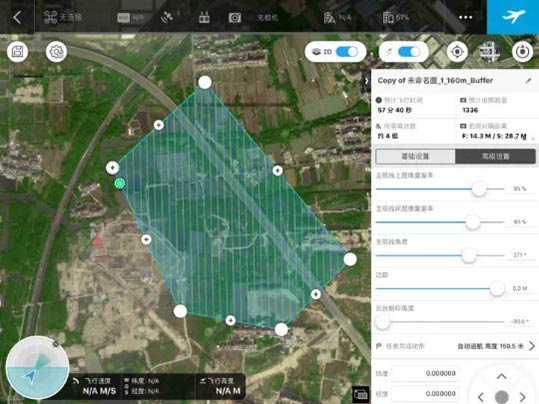
Flight Route Planning: Balancing Safety and Coverage
To ensure both flight safety and modeling accuracy:
- Altitude: A total of 160 m flight height with a 60 m safety margin above the tallest buildings.
- Overlap: 85% forward and 80% side overlap ensured complete rooftop coverage and avoided “broken” models.
- Flight speed: 9.8 m/s, achieving stability and efficiency—completing each flight in just 57 minutes.
3. Data Verification: From Aerial Triangulation to 3D Modeling
Aerial Triangulation Results
DG4Pros demonstrated outstanding precision and stability:
- Lens distortion: Minimal distortion—grid alignment between measured and standard targets was nearly perfect.
- RMS reprojection error: Only 0.55 pixels, far better than typical industry levels.
- Camera synchronization: Offset between central nadir and oblique cameras ≤ 4.37 cm, with synchronization accuracy within 5 ms, minimizing temporal shift errors.
- Tie point precision: Reprojection errors between 0.12–0.47 pixels, ensuring accurate stitching and reliable photogrammetric adjustment.
Modeling Results
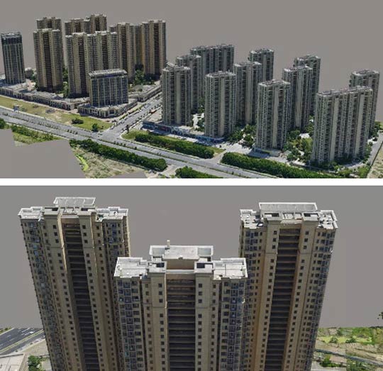
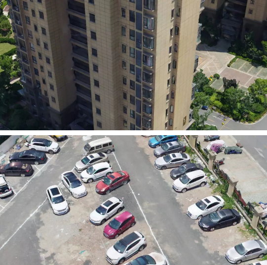
- Detail clarity: Long focal length enabled sharp representation of windows, doors, and building bases, with no ghosting or blur.
- Building footprint accuracy: Building base lines were smooth and well-defined—ideal for corner point extraction in cadastral mapping.
- Continuous coverage: With a 0.6 s minimum exposure interval, DG4Pros achieved full image continuity even under high overlap ratios.
4. Accuracy Validation: RMS Error of Only 0.041 m
To verify final model accuracy, 31 building corner points were checked via total station measurements and CAD comparison.
Validation Process
- Collect corner point coordinates in the field with a total station.
- Extract corresponding coordinates from the DG4Pros 3D model.
- Compare both datasets in CAD to calculate planimetric deviations and RMS error.
Results
- Single-point deviation: Minimum 1.5 cm, maximum <8.3 cm.
- Overall RMS error: 0.041 m, with zero gross errors—fully meeting the 1:500 cadastral mapping accuracy standard.
5. Project Significance and Future Outlook
This project not only validated the DG4Pros’ real-world performance but also marked an important technological breakthrough for urban high-rise cadastral mapping.
Core Contributions
- Breaking technical barriers: Solved the long-standing issue of insufficient accuracy and high operational risk in urban oblique photogrammetry.
- Efficiency improvement: Compared to traditional RTK surveying—often hindered by satellite signal obstruction—drone photogrammetry provides higher precision and far greater operational efficiency.
Future Development
Building on this success, Riebo will collaborate with more industry partners to expand the application scope of oblique photogrammetry. The company will continue refining its equipment to further enhance precision, efficiency, and usability—making DG4Pros a trusted tool for professionals in cadastral mapping, urban planning, and 3D city modeling.


