To support China’s national strategy for building the “3D Real-World China” geographic information system, the Economic Management Scientific Research Institute (Institute of Economic Management of Natural Resources) and the Shantou Natural Resource Survey Institute jointly led a large-scale city digital mapping project covering Shantou’s main urban area. This initiative integrated existing base geographic data with high-resolution oblique photogrammetry to produce a complete city-scale 3D geographic scene model at 1.5 cm resolution — the first of its kind fully implemented across an urban area in China.
Client Profiles
Economic Management Scientific Research Institute of the Ministry of Natural Resources A top-tier national surveying and mapping research institution with advanced qualifications and extensive surveying equipment. It plays a leading role in China’s oblique photogrammetry technical alliance and major geographic information technology research.
Shantou Natural Resource Survey Institute (Shantou Basic Geographic Information Center) A government-managed surveying and mapping center responsible for urban and regional mapping, cadastral surveys, land use planning support, and foundational geographic information system (GIS) management.
Survey Area and Challenges

The project focused on the Shantou urban core and surrounding developed areas. The survey area included diverse building heights and urban structures:
- Low-rise regions: Houses under 30 m tall with dense distribution.
- Mid-rise areas: Mixed buildings up to 80 m high with complex environments.
- High-rise zones: Tower blocks over 80 m tall, including densely packed downtown regions and ongoing construction sites.
- Special features: Two cross-sea bridges (Haibay Bridge and Qiaoshi Bridge), sports venues under construction, and small offshore island features.
Flight Strategy & Platform Selection
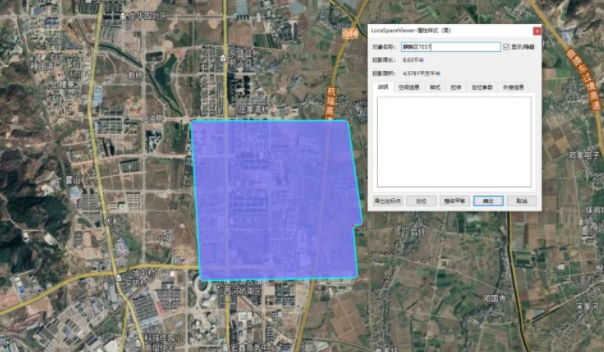
To meet 1.5 cm ground resolution requirements while ensuring flight safety and efficiency across a 174 km² study area, two UAV systems were deployed:
Flight Platforms
- DJI M300 RTK + Riebo D2-PSDK camera: Assigned to areas with building heights under 50 m.
- DJI M600 Pro + Riebo DG4 Pros camera: Assigned to high-rise areas above 50 m.
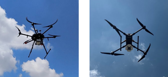
These complementary systems ensured optimal image quality, resolution, and model completeness while maintaining efficient operations.
Oblique Photogrammetry Imaging
Control & Precision
- Image control points were established using RTK/PPK positioning.
- Coverage density: ~5 control points per km² and ~15 checkpoints per km².
- Riebo optics demonstrated strong distortion control (≤ 0.004), improving aerial triangulation success and ensuring adherence to 1:500 cadastral precision standards.
Image Quality & Performance
- The Riebo DG4 Pros adjustable exposure and high optical fidelity improved photogrammetric consistency across variable light conditions, reducing over- and under-exposure issues.
- High fidelity color reproduction and stabilized imaging contributed to uniform model texture and detail.
Flight Parameters
- Project coverage: ~174 km² real operational area.
- Flight count: ~572 total sorties, capturing ~2,000,000 images.
- Flight speeds & durations:
- M300 RTK: ~8 m/s, ~35 min per sortie.
- M600 Pro: ~8 m/s, ~25 min per sortie.
Data Processing Workflow
Pre-Production
- Images were pre-processed with SkyScanner for accurate geolocation.
- Processing hardware included high-performance workstations (Intel i9, 2080 GPUs, 128 GB RAM).
- Aerial triangulation and 3D reconstruction were completed in Mirauge3D software.
Post-Processing Products
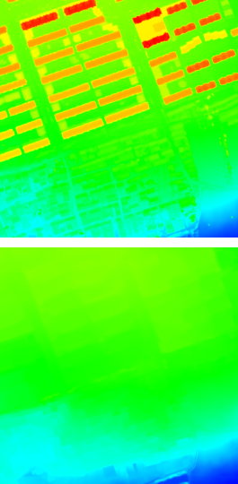
- OSGB color-blended 3D models: Used to unify color differences between neighboring zones.
- DOM / TDOM datasets: Produced from rectified vertical images.
- DSM & DEM outputs: Generated from classified point clouds.
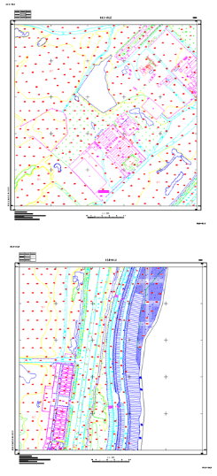
- 1:500 DLG vector layers & as-built maps: Extracted and validated for cadastral use.
Model Accuracy & Quality
Measured data from both UAV camera systems consistently met the 1:500 urban cadastral mapping standard, validating the reliability of Riebo imagery and processing workflows for large-scale city surveying.
Model Results & Applications
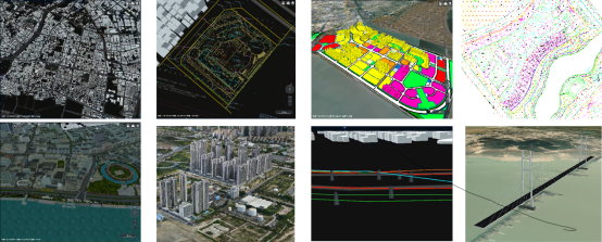
High-Fidelity 3D Real-World Urban Model
The project delivered an integrated city-scale 3D real-world geospatial model, enabling:
- Detailed visualization of complex urban structures from low to high rise.
- Support for urban spatial planning, land use analysis, and digital city infrastructure.
- Efficient rendering and visualization with node aggregation optimization for smooth performance.
Multi-Source Data Integration
Integration of datasets such as point clouds, BIM overlays, terrain models, CAD maps, underground infrastructure, and planning layers enabled comprehensive underground/above-ground spatial analysis and city-wide GIS services.
Major Project Monitoring & Progress Tracking
This case also supported project lifecycle monitoring, including construction progress, earthwork volume analysis, and BIM integration. Regular data captures were compared over three phases: design (2019), construction (2020), and completion (2021).
Key Takeaways
- Riebo’s oblique photogrammetry solution successfully supported large-area, urban-scale 3D mapping with strict precision standards.
- Effective use of multiple UAV platforms matched to regional urban morphology ensured both high resolution and efficient operation.
- High optical performance and workflow optimization significantly enhanced image matching and 3D reconstruction consistency.
- The project validated the feasibility of low-altitude UAV-based real-world 3D city mapping at a major metropolitan scale.