In the field of cadastral mapping, 1:500 accuracy is the industry’s benchmark standard. While multirotor drones equipped with oblique cameras have become a mature solution, Riebo has introduced a new level of innovation by combining the CW15 fixed-wing UAV with the DG4Pros oblique photogrammetry camera. This breakthrough achieves both high precision and high efficiency, setting a new standard for aerial cadastral mapping operations.
Project Background and Key Challenges
As cadastral projects increasingly demand higher operational efficiency, fixed-wing drones have gained attention for their high-speed flight advantage. However, achieving 1:500 mapping accuracy with fixed-wing UAVs and oblique cameras presents three major challenges:
- Image displacement (motion blur) caused by high-speed flight, introducing geometric errors.
- The need for high-speed image capture to match flight velocity.
- Extremely precise synchronization between multiple lenses, as even millisecond deviations can lead to noticeable positional errors.
To validate the feasibility of this fixed-wing + oblique camera configuration, Riebo conducted a dedicated technical verification project.
Project Implementation
Survey Area and Equipment
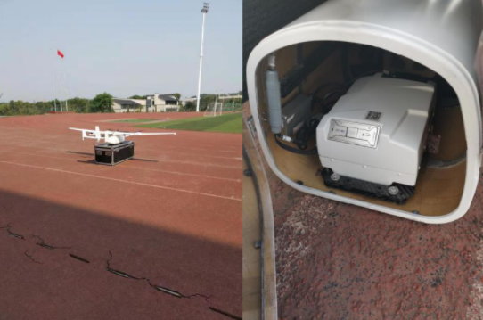
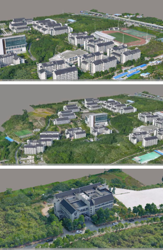
The test site was located at a school area in Chongqing, China, covering an effective mapping area of 0.73 km² and a flight coverage of 1.25 km². The area included dense buildings, tall structures, hills, and vegetation, with an elevation difference under 40 meters and the tallest building around 50 meters — providing an ideal, diverse test environment.
The project used the CW15 VTOL fixed-wing UAV paired with Riebo’s DG4Pros oblique photogrammetry camera. The DG4Pros features a highly integrated design compatible with most mainstream UAVs, allowing quick installation and setup.
Flight Planning and Preparation
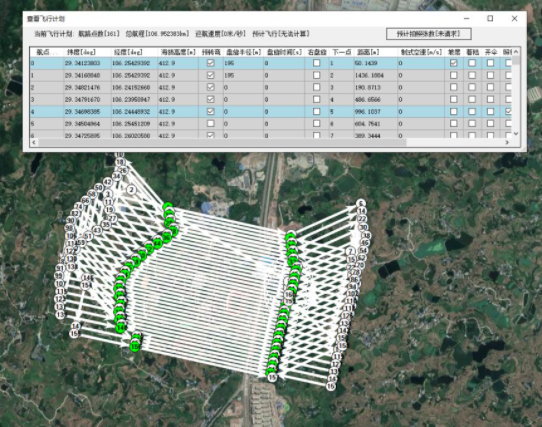
- Ground Control Points (GCPs): 34 control points were placed approximately every 150 meters according to cadastral accuracy standards.
- Flight Plan: The flight route was designed for 1.5 cm ground resolution, with 75% forward and side overlap to ensure full coverage.
- Site Setup: The UAV was assembled and calibrated within 10 minutes on an open school field, minimizing preparation time.
Flight and Data Acquisition
The CW15 UAV flew at 19 m/s (up to 23 m/s ground speed) and completed the entire 119 km route in one flight (90 minutes), capturing 12,175 images. All images were evenly exposed and sharp, with no missing data, providing a solid foundation for processing.
Data Processing and Accuracy Verification
Data Preprocessing
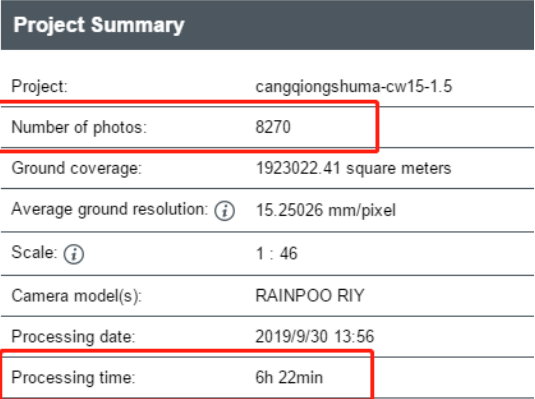
Using Sky-Filter software, redundant edge images were removed, retaining 8,255 effective photos (32.2% filtered). The dataset was then processed with Riebo’s proprietary Sky-AAC aerial triangulation software, completing bundle adjustment in about 4 hours with excellent results.
Thanks to DG4Pros’ advanced optical design, the RMS reprojection error was just 0.56 pixels, and camera synchronization precision was within 1.5 ms, effectively eliminating image-shift errors caused by high-speed motion.
Accuracy Validation
After model generation, the building corner points measured with a total station were compared with the model-derived coordinates. After excluding gross errors caused by vegetation or glass reflections, the final mean positional error was only 0.0239 m, fully meeting China’s 1:500 cadastral mapping accuracy standard and confirming the system’s reliability.
Project Summary and Product Advantages
The project’s success largely stems from the DG4Pros’ exceptional performance. With the fastest 0.6-second shooting interval in its class, ultra-low distortion lenses, and a high-precision synchronization module, DG4Pros effectively overcomes the challenges of image shift, capture rate, and timing in fixed-wing operations.
Compared to traditional multirotor workflows, this solution maintains precision while greatly improving efficiency — completing large-area mapping in a single flight.
DG4Pros has also demonstrated excellent results in previous high-rise cadastral modeling projects, achieving relative accuracy better than 5 cm even under GCP-free fixed-wing operations.
As a pioneer in oblique photogrammetry technology, Riebo continues to push industry boundaries through ongoing innovation, providing more accurate and efficient solutions for the geospatial industry, and driving the evolution of cadastral mapping toward higher quality and greater productivity.


